Percorso A piedi Anhée - Crèvecoeur - Photo

Randonnées du CGT GUIDE+

© OpenStreetMap contributors
Lunghezza
Lunghezza
12,8 km
Altitudine massima
Altitudine massima
223 m
Dislivello positivo
Dislivello positivo
242 m
Km-Effort
Km-Effort  
16 km
Altitudine minima
Altitudine minima
84 m
Dislivello negativo
Dislivello negativo
242 m
Boucle
Boucle
Sì
Data di creazione :
2022-02-08 11:32:04.784
Ultima modifica :
2022-02-21 10:13:24.552

(0 Recensione)

A piedi
A piedi
3h38
Difficoltà : Facile

Scannerizza questo codice QR per aprire il percorso nell'applicazione SityTrail

Applicazione GPS da escursionismo GRATUITA

Logo SityTrail SityTrail

IGN / Istituti geografici

Scarica SityTrail dall'App Store Scarica SityTrail da Google Play

Logo SityTrail SityTrail World

Il mondo è tuo

Scarica SityTrail dall'App Store Scarica SityTrail da Google Play Scarica SityTrail da Huawei AppGallery

Chi siamo

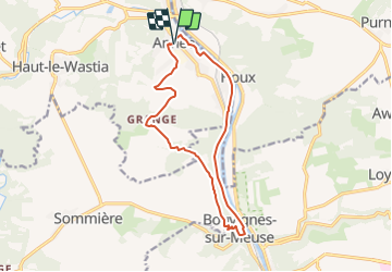
Percorso A piedi di 12,8 km da scoprire a Wallonie, Namur, Anhée. Questo percorso è proposto da Commissariat général au Tourisme.

Descrizione

Trail created by Vallée de la Meuse Namur-Dinant.


Departure : Place communale of Anhée.

Cross the main road under the protection of the traffic lights. Turn into the rue Ribot, then right into the rue Petit, extended by the rue des Fusillées. At the cross, turn right into rue Ste Barbe, cross the main road and continue on the road in front of you which leads you to the old Dinant-Tamines railway line. Follow this line to the left. Cross the main road. Join the junction with the Dinant-Namur line near the Houx bridge defended in 40 by the Ardennes hunters and whose fortress still exists. Follow the dirt road along the Namur-Dinant line. Take the "rue de l'écluse" which brings you close to the place used by the Germans to cross the Meuse. Join the towpath. After 2500 meters, pass under the railroad, shortly before the lock and join the pelota game. Follow the main road to the left, pass in front of the Amand de Mendieta castle (former convent of the Sépulchrines) and take the road to the right, the rue de Meez. Then to the right, the Richier street, so as to go along the ruins of the castle. When you arrive near the Place du Baillage, take a look at the Maison Espagnole (former house of the bailiff converted into a museum) and at the Fontaine du Marché. Take the stairs on the left, along the St-Lambert church. After the church, cross the road and take the path that leads to the ruins of Crèvecœur. After the ruins, continue on the path towards the farms of Grange. Note the commemorative plaque. Go back down to the right towards Senenne. Note the old tombstones. Go around the wall of the property, cross the Ry de Mazy, then take the path on the right, pass in front of the chapel of the Angel. Take the railroad back to your starting point.


Profilo altimetrico

Foto

Localizzazione

Paese:
Belgium
Regione :
Wallonie
Dipartimento/Provincia :
Namur
Comune :
Anhée
Località :
Unknown
Partenza:(UTM)
633701 ; 5574782 (31U) N.

Percorsi nelle vicinanze

Percorso Marcia Yvoir - RB-Na-21-Terres seigneuriales et carrières de la vallée du Bocq - Photo
Marcia
PRO

Marcia

Molto difficile
(6)
Yvoir, Wallonie, Namur, Belgium
22 km | 30 km-effort
6h 51min
Sì
Percorso Marcia Yvoir - RB-Na-03 Forteresses, citadelle et abbaye mosanes - Photo
Marcia
PRO

Marcia

Difficile
(10)
Yvoir, Wallonie, Namur, Belgium
22 km | 30 km-effort
7h 1min
Sì
Percorso Marcia Yvoir - GG2-Na-38_Godinne-Dinant (2021-11-04) - Photo
Marcia
PRO

Marcia

Molto difficile
(6)
Yvoir, Wallonie, Namur, Belgium
19,5 km | 27 km-effort
6h 13min
No
Percorso Marcia Anhée - RF-Na-05 Annevoie, côté Jardins_Grande-boucle - Photo
Marcia
PRO

Marcia

Medio
(11)
Anhée, Wallonie, Namur, Belgium
11,3 km | 14,5 km-effort
3h 6min
Sì
Percorso Marcia Anhée - RF-Na-05 Annevoie, côté Jardins_Petite-boucle - Photo
Marcia
PRO

Marcia

Facile
(7)
Anhée, Wallonie, Namur, Belgium
7,4 km | 10 km-effort
2h 7min
Sì
Percorso Marcia Onhaye - RB-Na-C2-Sommière-Complet_20,4km - Photo
Marcia
PRO

Marcia

Molto difficile
(2)
Onhaye, Wallonie, Namur, Belgium
20 km | 25 km-effort
5h 25min
Sì
Percorso Marcia Yvoir - RB-Na-21-raccourci-Terres seigneuriales et carrières de la vallée du Bocq - Photo
Marcia
PRO

Marcia

Molto difficile
(2)
Yvoir, Wallonie, Namur, Belgium
18,6 km | 25 km-effort
5h 43min
Sì
Percorso Marcia Yvoir - D'Yvoir à Evrehailles - Photo
Marcia
GUIDE
Desrumaux

Marcia

Facile
(2)
Yvoir, Wallonie, Namur, Belgium
9,9 km | 13,2 km-effort
2h 51min
Sì
Percorso Marcia Yvoir - De Godinne à Rivière par le point de vue des 7 Meuses - Photo
Marcia
GUIDE
Desrumaux

Marcia

Facile
(5)
Yvoir, Wallonie, Namur, Belgium
8,5 km | 11,6 km-effort
2h 30min
Sì


Chiudi
I miei abbonamenti