![](/images/other/stat-length.png)
![Percorso A piedi Bad Schandau - Rundweg Gelber Punkt - Photo](https://media.geolcdn.com/t/1900/400/ext.pjpeg?maxdim=2&url=https%3A%2F%2Fmedia.geolcdn.com%2Ff%2F691fe921-8767-4ac4-b4b2-0f3a82376aa7.jpeg)
Rundweg Gelber Punkt
SityTrail - itinéraires balisés pédestres
Tous les sentiers balisés d’Europe PRO
![Lunghezza](/images/other/stat-length.png)
Lunghezza
12,7 km
![Altitudine massima](https://static1.geolcdn.com/siteimages/upload/files/1508320355ic_sort_altitude_max_24dp.png)
Altitudine massima
270 m
![Dislivello positivo](https://static1.geolcdn.com/siteimages/upload/files/1508320355ic_sort_den_pos_24dp.png)
Dislivello positivo
360 m
![Km-Effort](/images/other/stat-length.png)
Km-Effort
17,5 km
![Altitudine minima](https://static1.geolcdn.com/siteimages/upload/files/1508320355ic_sort_altitude_min_24dp.png)
Altitudine minima
118 m
![Dislivello negativo](https://static1.geolcdn.com/siteimages/upload/files/1508320355ic_sort_den_neg_24dp.png)
Dislivello negativo
350 m
![Boucle](https://static1.geolcdn.com/siteimages/upload/files/16400158638029165_repeat_loop_refresh_sync_direction_icon.png)
Boucle
Sì
Tag
Data di creazione :
2022-02-11 17:45:04.437
Ultima modifica :
2022-02-11 17:45:04.437
![A piedi](https://static1.geolcdn.com/sitytour/trail-icons/100.png)
3h58
Difficoltà : Facile
![Scannerizza questo codice QR per aprire il percorso nell'applicazione SityTrail](https://capi.geolives.com/qq0zvz2zws4bq2lad0pu/sitytour/trails/3098471/qr.png?size=200)
Applicazione GPS da escursionismo GRATUITA
Chi siamo
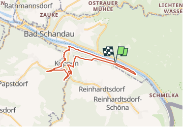
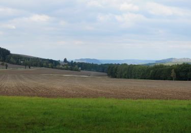
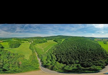
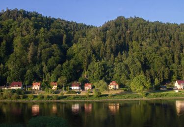
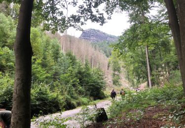
Percorso A piedi di 12,7 km da scoprire a Sassonia, Sächsische Schweiz-Osterzgebirge, Bad Schandau. Questo percorso è proposto da SityTrail - itinéraires balisés pédestres.
Descrizione
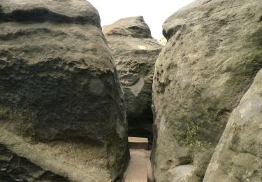
Symbol: Gelber Punkt auf weißem Grund
Localizzazione
Paese:
Germany
Regione :
Sassonia
Dipartimento/Provincia :
Sächsische Schweiz-Osterzgebirge
Comune :
Bad Schandau
Località :
Unknown
Partenza:(Dec)
Partenza:(UTM)
443637 ; 5639632 (33U) N.
Commenti
Percorsi nelle vicinanze
![Percorso A piedi Bad Schandau - Grüner Punkt - Photo](https://media.geolcdn.com/t/375/260/ext.jpg?maxdim=2&url=https%3A%2F%2Fmedia.geolcdn.com%2Ff%2F394526b7-5063-4e3f-985c-cb5ed76c61fc.jpeg)
![A piedi A piedi](https://static1.geolcdn.com/sitytour/trail-icons/100.png)
Grüner Punkt
A piedi
Medio
Bad Schandau,
Sassonia,
Sächsische Schweiz-Osterzgebirge,
Germany
![](/images/other/stat-length.png)
15 km | 22 km-effort
5h 6min
![](https://static1.geolcdn.com/siteimages/upload/files/16400158638029165_repeat_loop_refresh_sync_direction_icon.png)
No
![Percorso A piedi Bad Schandau - Grüner Strich - Photo](https://media.geolcdn.com/t/375/260/ext.jpg?maxdim=2&url=https%3A%2F%2Fmedia.geolcdn.com%2Ff%2F83b0edee-bbbe-4fcb-9879-8295d219ae61.jpeg)
![A piedi A piedi](https://static1.geolcdn.com/sitytour/trail-icons/100.png)
Grüner Strich
A piedi
Facile
Bad Schandau,
Sassonia,
Sächsische Schweiz-Osterzgebirge,
Germany
![](/images/other/stat-length.png)
9,6 km | 16,9 km-effort
3h 50min
![](https://static1.geolcdn.com/siteimages/upload/files/16400158638029165_repeat_loop_refresh_sync_direction_icon.png)
No
![Percorso A piedi Bad Schandau - Neustadt / Sa. - Kleiner Winterberg - Photo](https://media.geolcdn.com/t/375/260/ext.jpg?maxdim=2&url=https%3A%2F%2Fmedia.geolcdn.com%2Ff%2F4daf772d-b75f-45ed-a5ba-e28faeb9c54b.jpeg)
![A piedi A piedi](https://static1.geolcdn.com/sitytour/trail-icons/100.png)
Neustadt / Sa. - Kleiner Winterberg
A piedi
Facile
Bad Schandau,
Sassonia,
Sächsische Schweiz-Osterzgebirge,
Germany
![](/images/other/stat-length.png)
5,4 km | 8,3 km-effort
1h 52min
![](https://static1.geolcdn.com/siteimages/upload/files/16400158638029165_repeat_loop_refresh_sync_direction_icon.png)
No
![Percorso A piedi Gohrisch - Grüner Punkt, Sächsische Schweiz (linkselbisch) - Photo](https://media.geolcdn.com/t/375/260/ext.jpg?maxdim=2&url=https%3A%2F%2Fmedia.geolcdn.com%2Ff%2Fc92ac5f7-3302-44e2-b983-ea46cc789625.jpeg)
![A piedi A piedi](https://static1.geolcdn.com/sitytour/trail-icons/100.png)
Grüner Punkt, Sächsische Schweiz (linkselbisch)
A piedi
Facile
Gohrisch,
Sassonia,
Sächsische Schweiz-Osterzgebirge,
Germany
![](/images/other/stat-length.png)
12,8 km | 17,7 km-effort
4h 1min
![](https://static1.geolcdn.com/siteimages/upload/files/16400158638029165_repeat_loop_refresh_sync_direction_icon.png)
No
![Percorso A piedi Bad Schandau - Gelber Punkt, Panoramaweg - Photo](https://media.geolcdn.com/t/375/260/ext.jpg?maxdim=2&url=https%3A%2F%2Fmedia.geolcdn.com%2Ff%2Ff504cc0a-ead2-4174-bc3a-7a6e287b40e0.jpeg)
![A piedi A piedi](https://static1.geolcdn.com/sitytour/trail-icons/100.png)
Gelber Punkt, Panoramaweg
A piedi
Medio
Bad Schandau,
Sassonia,
Sächsische Schweiz-Osterzgebirge,
Germany
![](/images/other/stat-length.png)
15,6 km | 21 km-effort
4h 43min
![](https://static1.geolcdn.com/siteimages/upload/files/16400158638029165_repeat_loop_refresh_sync_direction_icon.png)
No
![Percorso A piedi Bad Schandau - Caspar-David-Friedrich-Weg - Photo](https://media.geolcdn.com/t/375/260/ext.jpg?maxdim=2&url=https%3A%2F%2Fmedia.geolcdn.com%2Ff%2F60a4212b-eea8-4634-b0b2-10003efddcaa.jpeg)
![A piedi A piedi](https://static1.geolcdn.com/sitytour/trail-icons/100.png)
Caspar-David-Friedrich-Weg
A piedi
Facile
Bad Schandau,
Sassonia,
Sächsische Schweiz-Osterzgebirge,
Germany
![](/images/other/stat-length.png)
3,5 km | 4 km-effort
54min
![](https://static1.geolcdn.com/siteimages/upload/files/16400158638029165_repeat_loop_refresh_sync_direction_icon.png)
No
![Percorso A piedi Reinhardtsdorf-Schöna - Rundweg Hundskirche - Photo](https://media.geolcdn.com/t/375/260/ext.jpg?maxdim=2&url=https%3A%2F%2Fstatic1.geolcdn.com%2Fsiteimages%2Fupload%2Ffiles%2F1545311037marcheuse_200dpi.jpg)
![A piedi A piedi](https://static1.geolcdn.com/sitytour/trail-icons/100.png)
Rundweg Hundskirche
A piedi
Facile
Reinhardtsdorf-Schöna,
Sassonia,
Sächsische Schweiz-Osterzgebirge,
Germany
![](/images/other/stat-length.png)
7,6 km | 9,5 km-effort
2h 9min
![](https://static1.geolcdn.com/siteimages/upload/files/16400158638029165_repeat_loop_refresh_sync_direction_icon.png)
Sì
![Percorso A piedi Bad Schandau - Lehrpfad im Elbsandsteingebirge - Photo](https://media.geolcdn.com/t/375/260/ext.jpg?maxdim=2&url=https%3A%2F%2Fstatic1.geolcdn.com%2Fsiteimages%2Fupload%2Ffiles%2F1545311037marcheuse_200dpi.jpg)
![A piedi A piedi](https://static1.geolcdn.com/sitytour/trail-icons/100.png)
Lehrpfad im Elbsandsteingebirge
A piedi
Facile
Bad Schandau,
Sassonia,
Sächsische Schweiz-Osterzgebirge,
Germany
![](/images/other/stat-length.png)
3,9 km | 5,1 km-effort
1h 9min
![](https://static1.geolcdn.com/siteimages/upload/files/16400158638029165_repeat_loop_refresh_sync_direction_icon.png)
No
![Percorso Marcia Hřensko - Randonnée en Suisse Bohème - Photo](https://media.geolcdn.com/t/375/260/ext.jpg?maxdim=2&url=https%3A%2F%2Fmedia.geolcdn.com%2Ff%2F83a179be-2761-43eb-8e69-ce2d0c167ed4.jpg)
![Marcia Marcia](https://static1.geolcdn.com/sitytour/trail-icons/101.png)
Randonnée en Suisse Bohème
Marcia
Medio
Hřensko,
Severozápad,
Ústecký kraj,
Czech Republic
![](/images/other/stat-length.png)
21 km | 31 km-effort
7h 13min
![](https://static1.geolcdn.com/siteimages/upload/files/16400158638029165_repeat_loop_refresh_sync_direction_icon.png)
Sì