Percorso Corsa a piedi Interlaken - Marathon_Jungfrau - Photo
 lhommep
lhommep

Utente

© OpenStreetMap contributors
Lunghezza
Lunghezza
42 km
Altitudine massima
Altitudine massima
2216 m
Dislivello positivo
Dislivello positivo
1999 m
Km-Effort
Km-Effort  
64 km
Altitudine minima
Altitudine minima
564 m
Dislivello negativo
Dislivello negativo
474 m
Boucle
Boucle
No
Data di creazione :
2014-12-10 00:00:00.0
Ultima modifica :
2014-12-10 00:00:00.0

(0 Recensione)

Corsa a piedi
Corsa a piedi
5h30
Difficoltà : Sconosciuto

Scannerizza questo codice QR per aprire il percorso nell'applicazione SityTrail

Applicazione GPS da escursionismo GRATUITA

Logo SityTrail SityTrail

IGN / Istituti geografici

Scarica SityTrail dall'App Store Scarica SityTrail da Google Play

Logo SityTrail SityTrail World

Il mondo è tuo

Scarica SityTrail dall'App Store Scarica SityTrail da Google Play Scarica SityTrail da Huawei AppGallery

Chi siamo

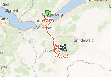
Percorso Corsa a piedi di 42 km da scoprire a Berna, Verwaltungskreis Interlaken-Oberhasli, Interlaken. Questo percorso è proposto da lhommep.

Profilo altimetrico

Punti di interesse

Punto di interesse Lauterbrunnen - poi_295661 - Photo
lhommep
LAUTERBRUNNEN 
Punto di interesse Lauterbrunnen - Semi-Marathon - Photo
lhommep
LAUTERBRUNNEN 
Punto di interesse Lauterbrunnen - Km 26 - Photo
lhommep
LAUTERBRUNNEN 
Punto di interesse Lauterbrunnen - Km 30 - Photo
lhommep
LAUTERBRUNNEN 
Punto di interesse Lauterbrunnen - Km 35 - Photo
lhommep
LAUTERBRUNNEN 
Punto di interesse Lauterbrunnen - Km 40 - Photo
lhommep
LAUTERBRUNNEN 
Punto di interesse Interlaken - Départ - Photo
lhommep
INTERLAKEN 
Punto di interesse Interlaken - Km 5 - Photo
lhommep
INTERLAKEN 
Punto di interesse Wilderswil - Km 10 - Photo
lhommep
WILDERSWIL 
Punto di interesse Gündlischwand - Km 15 - Photo
lhommep
GÜNDLISCHWAND 
Punto di interesse Interlaken - Ravito - Photo
lhommep
INTERLAKEN 
Punto di interesse Wilderswil - Ravito - Photo
lhommep
WILDERSWIL 
Punto di interesse Lauterbrunnen - Ravito - Photo
lhommep
LAUTERBRUNNEN 
Punto di interesse Lauterbrunnen - Ravito - Photo
lhommep
LAUTERBRUNNEN 
Punto di interesse Lauterbrunnen - Ravito - Photo
lhommep
LAUTERBRUNNEN 
Punto di interesse Lauterbrunnen - Arrivée - Photo
lhommep
LAUTERBRUNNEN 
Punto di interesse Gündlischwand - Ravito - Photo
lhommep
GÜNDLISCHWAND 
Punto di interesse Lauterbrunnen - Ravito - Photo
lhommep
LAUTERBRUNNEN 
Punto di interesse Lauterbrunnen - Ravito - Photo
lhommep
LAUTERBRUNNEN 
Punto di interesse Lauterbrunnen - Ravito - Photo
lhommep
LAUTERBRUNNEN 
Punto di interesse Lauterbrunnen - Ravito - Photo
lhommep
LAUTERBRUNNEN 
Punto di interesse Lauterbrunnen - Ravito - Photo
lhommep
LAUTERBRUNNEN 

Localizzazione

Paese:
Switzerland
Regione :
Berna
Dipartimento/Provincia :
Verwaltungskreis Interlaken-Oberhasli
Comune :
Interlaken
Località :
Unknown
Partenza:(Dec)
Partenza:(UTM)
412743 ; 5171000 (32T) N.

Percorsi nelle vicinanze

Percorso A piedi Habkern - Habkern - Bärenei - Photo
A piedi
PRO

A piedi

Facile
Habkern, Berna, Verwaltungskreis Interlaken-Oberhasli, Switzerland
3,6 km | 9,6 km-effort
2h 11min
No
Percorso Marcia Gündlischwand - Schynige Platte chemin panoramique 06.07.15 - Photo
Marcia
duamerg

Marcia

Medio
Gündlischwand, Berna, Verwaltungskreis Interlaken-Oberhasli, Switzerland
7,4 km | 11,7 km-effort
3h 0min
Sì
Percorso Marcia Unterseen - Randonnée au dessus de Harder Kulm - Photo
Marcia
dudu42

Marcia

Difficile
Unterseen, Berna, Verwaltungskreis Interlaken-Oberhasli, Switzerland
6,4 km | 11,4 km-effort
2h 42min
No
Percorso Altra attività Unterseen - sf10_e7c - Photo
Altra attività
GUIDE+

Altra attività

Molto facile
Unterseen, Berna, Verwaltungskreis Interlaken-Oberhasli, Switzerland
24 km | 36 km-effort
8h 25min
No
Percorso Altra attività Habkern - sf10_e7b - Photo
Altra attività
GUIDE+

Altra attività

Molto facile
Habkern, Berna, Verwaltungskreis Interlaken-Oberhasli, Switzerland
23 km | 40 km-effort
8h 48min
No
Percorso Bicicletta Interlaken - st_ral_3 - Photo
Bicicletta
GUIDE+

Bicicletta

Molto facile
Interlaken, Berna, Verwaltungskreis Interlaken-Oberhasli, Switzerland
59 km | 69 km-effort
Sconosciuto
No
Percorso Marcia Habkern - Hohgant: Schrattenkalk und Meringeberge - Photo
Marcia
GUIDE+

Marcia

Molto facile
Habkern, Berna, Verwaltungskreis Interlaken-Oberhasli, Switzerland
17,3 km | 33 km-effort
Sconosciuto
No
Percorso Marcia Gündlischwand - Eiger, Mönch und Jungfrau im Blickfeld - Photo
Marcia
GUIDE+

Marcia

Molto facile
Gündlischwand, Berna, Verwaltungskreis Interlaken-Oberhasli, Switzerland
15,9 km | 27 km-effort
Sconosciuto
No
Percorso Mountainbike Habkern - Bike32898 - Photo
Mountainbike
GUIDE+

Mountainbike

Molto facile
Habkern, Berna, Verwaltungskreis Interlaken-Oberhasli, Switzerland
41 km | 61 km-effort
Sconosciuto
Sì


Chiudi
I miei abbonamenti