


L'abbaye

raymondfn
Utilisateur
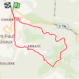

Longueur
8,5 km

Altitude max
764 m

Dénivelé positif
333 m
Km-Effort
13 km

Altitude min
480 m

Dénivelé négatif
334 m
Boucle
Oui
Date de création :
2019-01-03 22:01:05.235
Dernière modification :
2019-01-03 22:01:05.235
2h42
Difficulté : Moyen

Application GPS de randonnée GRATUITE
 SityTrail
IGN / Instituts géographiques
SityTrail Plus
Le monde est à vous
À propos
Randonnée Marche de 8,5 km à découvrir à Auvergne-Rhône-Alpes, Isère, Izeaux. Cette randonnée est proposée par raymondfn.
Localisation
Pays :
France
Région :
Auvergne-Rhône-Alpes
Département/Province :
Isère
Commune :
Izeaux
Localité :
Unknown
Départ:(Dec)
Départ:(UTM)
690726 ; 5022164 (31T) N.
Commentaires