Randonnée V.T.T. Châtenois - Chemin des Cols - Photo
 julu
julu

Utilisateur

© OpenStreetMap contributors
Longueur
Longueur
63 km
Altitude max
Altitude max
1104 m
Dénivelé positif
Dénivelé positif
1520 m
Km-Effort
Km-Effort  
83 km
Altitude min
Altitude min
183 m
Dénivelé négatif
Dénivelé négatif
1521 m
Boucle
Boucle
Oui
Date de création :
2018-09-14 06:44:47.548
Dernière modification :
2018-09-14 06:44:47.548

(0 Avis)

V.T.T.
V.T.T.
7h33
Difficulté : Inconnu

Scannez ce code QR pour ouvrir la randonnée dans l'application SityTrail

Application GPS de randonnée GRATUITE

Logo SityTrail SityTrail

IGN / Instituts géographiques

Télécharger SityTrail sur l'App Store Télécharger SityTrail sur Google Play

Logo SityTrail SityTrail World

Le monde est à vous

Télécharger SityTrail sur l'App Store Télécharger SityTrail sur Google Play Télécharger SityTrail sur Huawei AppGallery

À propos

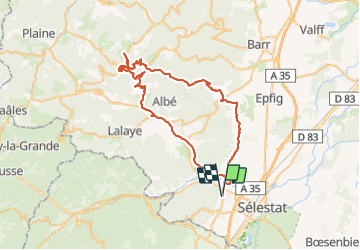
Randonnée V.T.T. de 63 km à découvrir à Grand Est, Bas-Rhin, Châtenois. Cette randonnée est proposée par julu.

Description

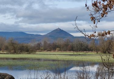
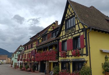
Chatenois Dambach Champ du feu Breitenbach Thanville

Profil altimétrique

Localisation

Pays :
France
Région :
Grand Est
Département/Province :
Bas-Rhin
Commune :
Châtenois
Localité :
Unknown
Départ:(Dec)
Départ:(UTM)
381193 ; 5347503 (32U) N.

Randonnées à proximité

Randonnée Marche Châtenois - Le Hahnenberg et les balcons Sélestat - Photo
Marche
VacheKiri67

Marche

Moyen
(2)
Châtenois, Grand Est, Bas-Rhin, France
12 km | 17,2 km-effort
4h 29min
Oui
Randonnée Marche Sélestat - Sentier de l'Illwald - Photo
Marche
tracegps

Marche

Moyen
(1)
Sélestat, Grand Est, Bas-Rhin, France
13,2 km | 14,6 km-effort
3h 45min
Oui
Randonnée Marche Châtenois - Le Haut Koenigsbourg de Val de Ville - Photo
Marche
tracegps

Marche

Difficile
(1)
Châtenois, Grand Est, Bas-Rhin, France
16,8 km | 25 km-effort
5h 0min
Oui
Randonnée Marche Kintzheim - 2023-10-15 Marche Haut Koenigsbourg - Photo
Marche
GUIDE
holtzv

Marche

Moyen
Kintzheim, Grand Est, Bas-Rhin, France
18,5 km | 28 km-effort
6h 16min
Oui
Randonnée Marche Saint-Hippolyte - St hippolyte ht koenigsbourg - Photo
Marche
legereric

Marche

Moyen
(2)
Saint-Hippolyte, Grand Est, Haut-Rhin, France
12 km | 18,7 km-effort
3h 27min
Oui
Randonnée Marche Scherwiller - chateau  de ortenbourg - Photo
Marche
dudu42

Marche

Très facile
(1)
Scherwiller, Grand Est, Bas-Rhin, France
4,6 km | 7,9 km-effort
1h 29min
Oui
Randonnée Marche Saint-Hippolyte - St-Hippolyte - Rorschwihr - Grasberg - Bergheim - Reichenberg - Rodern - Photo
Marche
VacheKiri67

Marche

Moyen
Saint-Hippolyte, Grand Est, Haut-Rhin, France
17,3 km | 22 km-effort
4h 28min
Oui
Randonnée Marche Sélestat - Sélestat : balade dans le Ried - Photo
Marche
Bart2015

Marche

Difficile
Sélestat, Grand Est, Bas-Rhin, France
11,4 km | 12,6 km-effort
2h 51min
Oui
Randonnée Vélo électrique Sélestat - Vignoble  - Photo
Vélo électrique
apa

Vélo électrique

Très facile
Sélestat, Grand Est, Bas-Rhin, France
50 km | 57 km-effort
3h 4min
Non


Fermer
Mes abonnements