Randonnée Marche Lacapelle-Marival - Lacapelle Merival vers Gramat - Photo

Lacapelle Merival vers Gramat

 choubaka77
choubaka77

Utilisateur

© OpenStreetMap contributors
Longueur
Longueur
24 km
Altitude max
Altitude max
416 m
Dénivelé positif
Dénivelé positif
366 m
Km-Effort
Km-Effort  
29 km
Altitude min
Altitude min
284 m
Dénivelé négatif
Dénivelé négatif
440 m
Boucle
Boucle
Non
Date de création :
2018-04-16 21:34:08.17
Dernière modification :
2018-04-16 21:34:08.17

(0 Avis)

Marche
Marche
6h45
Difficulté : Moyen

Scannez ce code QR pour ouvrir la randonnée dans l'application SityTrail

Application GPS de randonnée GRATUITE

Logo SityTrail SityTrail

IGN / Instituts géographiques

Télécharger SityTrail sur l'App Store Télécharger SityTrail sur Google Play

Logo SityTrail SityTrail World

Le monde est à vous

Télécharger SityTrail sur l'App Store Télécharger SityTrail sur Google Play Télécharger SityTrail sur Huawei AppGallery

À propos

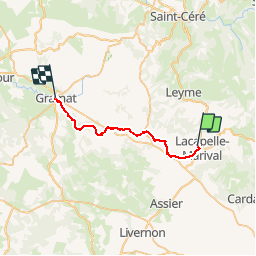
Randonnée Marche de 24 km à découvrir à Occitanie, Lot, Lacapelle-Marival. Cette randonnée est proposée par choubaka77.

Description

Ville sympa avec un très beau château. Départ difficile vers Gramat, chemin sans grand intérêt. Une pose bien venue à la halte de Thermines seul hébergement/restauration avant Gramat. Des gérants super sympa et pour finir nous retrouvons en sortie du village un chemin ou nous retrouvons le plaisir de marcher jusqu'à Gramat.

Profil altimétrique

Photos

Localisation

Pays :
France
Région :
Occitanie
Département/Province :
Lot
Commune :
Lacapelle-Marival
Localité :
Unknown
Départ:(Dec)
Départ:(UTM)
414348 ; 4953810 (31T) N.

Randonnées à proximité

Randonnée Marche Sonac - Theminettes Les Causses - Photo
Marche
gannet1

Marche

Facile
(4)
Sonac, Occitanie, Lot, France
14,6 km | 17,3 km-effort
3h 46min
Non
Randonnée Marche Rudelle - rudelle - Photo
Marche
thomas.o.vert

Marche

Facile
Rudelle, Occitanie, Lot, France
9,3 km | 11,6 km-effort
2h 17min
Oui
Randonnée Autre activité Lacapelle-Marival - Atlamed lacapelle marival - figeac  - Photo
Autre activité
jbtregouet

Autre activité

Facile
Lacapelle-Marival, Occitanie, Lot, France
23 km | 30 km-effort
5h 13min
Non
Randonnée Moto-cross Le Bourg - balade Trezebens emmanuel - Photo
Moto-cross
myburn

Moto-cross

Moyen
Le Bourg, Occitanie, Lot, France
15,7 km | 21 km-effort
54min
Oui
Randonnée Marche Lacapelle-Marival - Lacapelle-Merival/ Gramat - Photo
Marche
Jean CORBERON

Marche

Moyen
Lacapelle-Marival, Occitanie, Lot, France
26 km | 30 km-effort
21h 31min
Non
Randonnée Marche Lacapelle-Marival - 46_Lacapelle Marival_Gramat_j3 - Photo
Marche
jab31

Marche

Moyen
Lacapelle-Marival, Occitanie, Lot, France
25 km | 30 km-effort
8h 10min
Non
Randonnée Marche Lacapelle-Marival - StJ-J25-Lacapelle Marival-Gramat - Photo
Marche
Bonsaicd

Marche

Très difficile
Lacapelle-Marival, Occitanie, Lot, France
23 km | 27 km-effort
5h 46min
Non
Randonnée Marche Lacapelle-Marival - lacapelle-Marival - gramat - Photo
Marche
BernardBlin

Marche

Moyen
Lacapelle-Marival, Occitanie, Lot, France
25 km | 30 km-effort
6h 11min
Non
Randonnée Marche Théminettes - Theminettes mise en jambes - Photo
Marche
gannet1

Marche

Facile
Théminettes, Occitanie, Lot, France
5,4 km | 6,8 km-effort
1h 28min
Oui


Fermer
Mes abonnements