


VTT(74)-Verchaix - Sixt

HG74250
Gebruiker
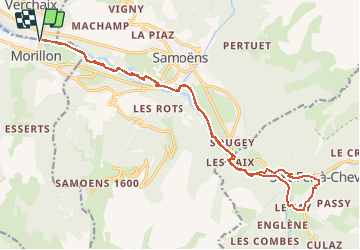

Lengte
21 km

Max. hoogte
825 m

Positief hoogteverschil
434 m
Km-Effort
27 km

Min. hoogte
668 m

Negatief hoogteverschil
434 m
Boucle
Ja
Datum van aanmaak :
2019-01-15 13:02:15.934
Laatste wijziging :
2020-01-04 17:36:54.076
1h46
Moeilijkheid : Gemakkelijk

Gratisgps-wandelapplicatie
 SityTrail
IGN / Geografische instituten
SityTrail Plus
De wereld gaat voor u open
Over ons
Tocht Mountainbike van 21 km beschikbaar op Auvergne-Rhône-Alpes, Haute-Savoie, Morillon. Deze tocht wordt voorgesteld door HG74250.
Plaatsbepaling
Land:
France
Regio :
Auvergne-Rhône-Alpes
Departement/Provincie :
Haute-Savoie
Gemeente :
Morillon
Locatie:
Unknown
Vertrek:(Dec)
Vertrek:(UTM)
320554 ; 5106374 (32T) N.
Opmerkingen