


2018 07 Camp mono

staubalex
Gebruiker
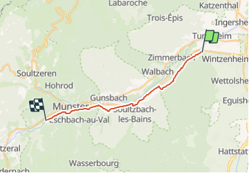

Lengte
15 km

Max. hoogte
410 m

Positief hoogteverschil
282 m
Km-Effort
18,2 km

Min. hoogte
245 m

Negatief hoogteverschil
122 m
Boucle
Neen
Datum van aanmaak :
2019-01-15 13:06:38.105
Laatste wijziging :
2019-01-15 13:06:38.105
1h14
Moeilijkheid : Gemakkelijk

Gratisgps-wandelapplicatie
 SityTrail
IGN / Geografische instituten
SityTrail Plus
De wereld gaat voor u open
Over ons
Tocht Andere activiteiten van 15 km beschikbaar op Grand Est, Haut-Rhin, Wintzenheim. Deze tocht wordt voorgesteld door staubalex.
Plaatsbepaling
Land:
France
Regio :
Grand Est
Departement/Provincie :
Haut-Rhin
Gemeente :
Wintzenheim
Locatie:
Unknown
Vertrek:(Dec)
Vertrek:(UTM)
370988 ; 5326273 (32U) N.
Opmerkingen