Tocht Mountainbike Toulouse - Canal du Midi - Toulouse --> Vic - Photo

Canal du Midi - Toulouse --> Vic

 tracegps
tracegps

Gebruiker

© OpenStreetMap contributors
Lengte
Lengte
14 km
Max. hoogte
Max. hoogte
164 m
Positief hoogteverschil
125 m
Km-Effort
Km-Effort  
15,7 km
Min. hoogte
Min. hoogte
144 m
Negatief hoogteverschil
116 m
Boucle
Boucle
Neen
Datum van aanmaak :
2014-12-10 00:00:00.0
Laatste wijziging :
2014-12-10 00:00:00.0

(0 Bericht)

Mountainbike
Mountainbike
1h00
Moeilijkheid : Gemakkelijk

Scan deze QR-code om de tocht te openen in de SityTrail-applicatie

Gratisgps-wandelapplicatie

Logo SityTrail SityTrail

IGN / Geografische instituten

SityTrail uit de App Store downloaden SityTrail uit Google Play downloaden

Logo SityTrail SityTrail World

De wereld gaat voor u open

SityTrail uit de App Store downloaden SityTrail uit Google Play downloaden SityTrail op Huawei AppGallery downloaden

Over ons

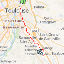
Tocht Mountainbike van 14 km beschikbaar op Occitanië, Haute-Garonne, Toulouse. Deze tocht wordt voorgesteld door tracegps.

Beschrijving

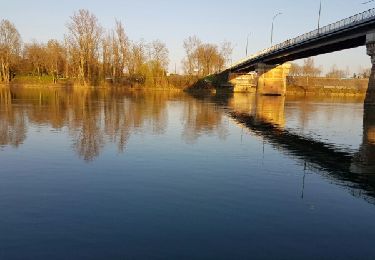
Circuit découverte Canal du Midi Circuit facile mais très fréquenté. Soyez vigilent et courtois. Dénivelé positif 50m environ. D'autres informations disponibles chez les Randoactifs.

Hoogteprofiel

POI's

POI Toulouse - E Bayard - Photo
tracegps
TOULOUSE 
POI Castanet-Tolosan - E Castanet - Photo
tracegps
CASTANET-TOLOSAN 
POI Castanet-Tolosan - E Vic - Photo
tracegps
CASTANET-TOLOSAN 

Plaatsbepaling

Land:
France
Regio :
Occitanië
Departement/Provincie :
Haute-Garonne
Gemeente :
Toulouse
Locatie:
Unknown
Vertrek:(Dec)
Vertrek:(UTM)
375132 ; 4829870 (31T) N.

Wandeltochten in de omgeving

Tocht Mountainbike L'Union - Fil Vert VTT du Grand Toulouse - Edition 2008 - 65km - Photo
Mountainbike
tracegps

Mountainbike

Moeilijk
(1)
L'Union, Occitanië, Haute-Garonne, France
66 km | 72 km-effort
4h 30min
Ja
Tocht Stappen Toulouse - De Toulouse à Bouconne par le GR653 - Photo
Stappen
tracegps

Stappen

Moeilijk
(1)
Toulouse, Occitanië, Haute-Garonne, France
21 km | 24 km-effort
5h 0min
Neen
Tocht Fiets Toulouse - Canal du Midi - Photo
Fiets
frizou83

Fiets

Heel gemakkelijk
(1)
Toulouse, Occitanië, Haute-Garonne, France
259 km | 281 km-effort
15h 55min
Neen
Tocht Stappen Toulouse - Tour de Toulouse par la Garonne  - Photo
Stappen
CooolGeorges

Stappen

Medium
Toulouse, Occitanië, Haute-Garonne, France
9,3 km | 11 km-effort
2h 35min
Ja
Tocht Stappen Toulouse - Blagnac sejour Eve  - Photo
Stappen
gergovie

Stappen

Gemakkelijk
Toulouse, Occitanië, Haute-Garonne, France
7,1 km | 7,7 km-effort
2h 21min
Ja
Tocht Stappen Toulouse - Toulouse - Pinsaguel  - Photo
Stappen
zazibelle

Stappen

Gemakkelijk
(1)
Toulouse, Occitanië, Haute-Garonne, France
15,6 km | 17,5 km-effort
4h 59min
Neen
Tocht Stappen Blagnac - Blagnac, le long de la Garonne  - Photo
Stappen
phil88

Stappen

Gemakkelijk
Blagnac, Occitanië, Haute-Garonne, France
5,3 km | 5,9 km-effort
1h 48min
Ja
Tocht Fiets Toulouse - Canal du Midi - Etape 1 - Photo
Fiets
frizou83

Fiets

Heel gemakkelijk
Toulouse, Occitanië, Haute-Garonne, France
55 km | 61 km-effort
3h 28min
Neen
Tocht Stappen Toulouse - Rive Droite Garonne Toulouse Gagnac - Photo
Stappen
RR31

Stappen

Gemakkelijk
Toulouse, Occitanië, Haute-Garonne, France
24 km | 27 km-effort
5h 55min
Neen


Sluiten
Mijn abonnementen