


Seuilly - Lerné la Roche-Clermault - 21.2km 215m 4h40 - public

Orcal37
Gebruiker GUIDE
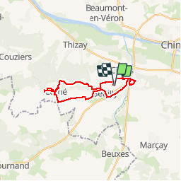

Lengte
21 km

Max. hoogte
113 m

Positief hoogteverschil
214 m
Km-Effort
24 km

Min. hoogte
33 m

Negatief hoogteverschil
213 m
Boucle
Ja
Datum van aanmaak :
2019-01-15 14:08:58.317
Laatste wijziging :
2019-08-18 08:54:31.552
4h40
Moeilijkheid : Gemakkelijk

Gratisgps-wandelapplicatie
 SityTrail
IGN / Geografische instituten
SityTrail Plus
De wereld gaat voor u open
Over ons
Tocht Stappen van 21 km beschikbaar op Centre-Val de Loire, Indre-et-Loire, Seuilly. Deze tocht wordt voorgesteld door Orcal37.
Beschrijving
Seuilly - Lerné la Roche-Clermault - 21.2km 2150m 4h40 - public
Foto's


Plaatsbepaling
Land:
France
Regio :
Centre-Val de Loire
Departement/Provincie :
Indre-et-Loire
Gemeente :
Seuilly
Locatie:
Unknown
Vertrek:(Dec)
Vertrek:(UTM)
286146 ; 5224490 (31T) N.
Opmerkingen