


lac daude_mt llaret

jcmartin
Gebruiker
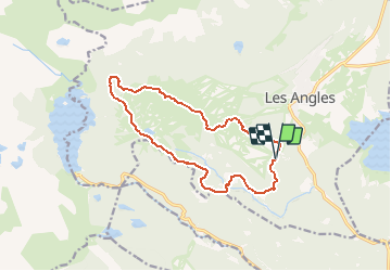

Lengte
14,2 km

Max. hoogte
2367 m

Positief hoogteverschil
632 m
Km-Effort
23 km

Min. hoogte
1798 m

Negatief hoogteverschil
631 m
Boucle
Ja
Datum van aanmaak :
2019-01-15 14:49:42.351
Laatste wijziging :
2020-08-02 09:18:12.561
4h46
Moeilijkheid : Medium

Gratisgps-wandelapplicatie
 SityTrail
IGN / Geografische instituten
SityTrail Plus
De wereld gaat voor u open
Over ons
Tocht Stappen van 14,2 km beschikbaar op Occitanië, Pyrénées-Orientales, Les Angles. Deze tocht wordt voorgesteld door jcmartin.


Plaatsbepaling
Land:
France
Regio :
Occitanië
Departement/Provincie :
Pyrénées-Orientales
Gemeente :
Les Angles
Locatie:
Unknown
Vertrek:(Dec)
Vertrek:(UTM)
423284 ; 4712740 (31T) N.
Opmerkingen