


J4 ERIC ETOILE QUINCIE 25K

ophness
Gebruiker
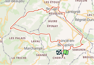

Lengte
24 km

Max. hoogte
817 m

Positief hoogteverschil
905 m
Km-Effort
36 km

Min. hoogte
239 m

Negatief hoogteverschil
897 m
Boucle
Ja
Datum van aanmaak :
2019-01-15 14:58:43.029
Laatste wijziging :
2019-01-15 14:58:43.029
9h24
Moeilijkheid : Onbekend

Gratisgps-wandelapplicatie
 SityTrail
IGN / Geografische instituten
SityTrail Plus
De wereld gaat voor u open
Over ons
Tocht Paard van 24 km beschikbaar op Auvergne-Rhône-Alpes, Rhône, Quincié-en-Beaujolais. Deze tocht wordt voorgesteld door ophness.
Plaatsbepaling
Land:
France
Regio :
Auvergne-Rhône-Alpes
Departement/Provincie :
Rhône
Gemeente :
Quincié-en-Beaujolais
Locatie:
Unknown
Vertrek:(Dec)
Vertrek:(UTM)
624399 ; 5106776 (31T) N.
Opmerkingen