


180822 vélo

benoit48
Gebruiker
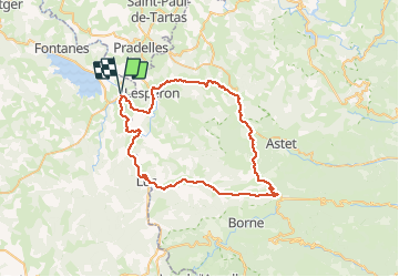

Lengte
59 km

Max. hoogte
1432 m

Positief hoogteverschil
952 m
Km-Effort
72 km

Min. hoogte
903 m

Negatief hoogteverschil
951 m
Boucle
Ja
Datum van aanmaak :
2019-01-15 15:05:36.725
Laatste wijziging :
2019-05-08 17:18:55.739
--
Moeilijkheid : Onbekend

Gratisgps-wandelapplicatie
 SityTrail
IGN / Geografische instituten
SityTrail Plus
De wereld gaat voor u open
Over ons
Tocht Fiets van 59 km beschikbaar op Occitanië, Lozère, Langogne. Deze tocht wordt voorgesteld door benoit48.
Plaatsbepaling
Land:
France
Regio :
Occitanië
Departement/Provincie :
Lozère
Gemeente :
Langogne
Locatie:
Unknown
Vertrek:(Dec)
Vertrek:(UTM)
568113 ; 4953222 (31T) N.
Opmerkingen