


Theux

Lychee
Gebruiker
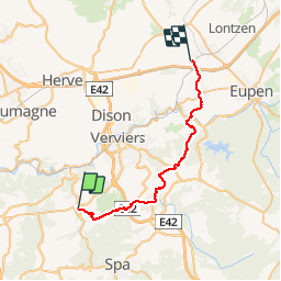

Lengte
28 km

Max. hoogte
389 m

Positief hoogteverschil
648 m
Km-Effort
37 km

Min. hoogte
167 m

Negatief hoogteverschil
564 m
Boucle
Neen
Datum van aanmaak :
2019-03-14 09:53:02.903
Laatste wijziging :
2019-03-14 15:13:51.658
7h27
Moeilijkheid : Moeilijk

Gratisgps-wandelapplicatie
 SityTrail
IGN / Geografische instituten
SityTrail Plus
De wereld gaat voor u open
Over ons
Tocht Stappen van 28 km beschikbaar op Wallonië, Luik, Theux. Deze tocht wordt voorgesteld door Lychee.
Beschrijving
au départ de Theux retour sur Welky
Foto's


Plaatsbepaling
Land:
Belgium
Regio :
Wallonië
Departement/Provincie :
Luik
Gemeente :
Theux
Locatie:
Theux
Vertrek:(Dec)
Vertrek:(UTM)
699470 ; 5602106 (31U) N.
Opmerkingen