


sitytrail 2009663 hunspach seebach inversé

anniston
Gebruiker
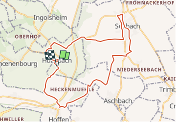

Lengte
18,8 km

Max. hoogte
190 m

Positief hoogteverschil
208 m
Km-Effort
22 km

Min. hoogte
137 m

Negatief hoogteverschil
207 m
Boucle
Ja
Datum van aanmaak :
2019-01-15 16:04:14.877
Laatste wijziging :
2019-01-15 16:04:14.877
4h00
Moeilijkheid : Onbekend

Gratisgps-wandelapplicatie
 SityTrail
IGN / Geografische instituten
SityTrail Plus
De wereld gaat voor u open
Over ons
Tocht Andere activiteiten van 18,8 km beschikbaar op Grand Est, Bas-Rhin, Hunspach. Deze tocht wordt voorgesteld door anniston.
Plaatsbepaling
Land:
France
Regio :
Grand Est
Departement/Provincie :
Bas-Rhin
Gemeente :
Hunspach
Locatie:
Unknown
Vertrek:(Dec)
Vertrek:(UTM)
422571 ; 5422516 (32U) N.
Opmerkingen