Tocht Stappen Givenchy-le-Noble - Givenchy le Noble - Ambrines - Denier - Lignereuil - Photo

Givenchy le Noble - Ambrines - Denier - Lignereuil

 tracegps
tracegps

Gebruiker

© OpenStreetMap contributors
Lengte
Lengte
11 km
Max. hoogte
Max. hoogte
154 m
Positief hoogteverschil
109 m
Km-Effort
Km-Effort  
12,5 km
Min. hoogte
Min. hoogte
103 m
Negatief hoogteverschil
106 m
Boucle
Boucle
Ja
Datum van aanmaak :
2014-12-10 00:00:00.0
Laatste wijziging :
2014-12-10 00:00:00.0

(0 Bericht)

Stappen
Stappen
2h00
Moeilijkheid : Medium

Scan deze QR-code om de tocht te openen in de SityTrail-applicatie

Gratisgps-wandelapplicatie

Logo SityTrail SityTrail

IGN / Geografische instituten

SityTrail uit de App Store downloaden SityTrail uit Google Play downloaden

Logo SityTrail SityTrail World

De wereld gaat voor u open

SityTrail uit de App Store downloaden SityTrail uit Google Play downloaden SityTrail op Huawei AppGallery downloaden

Over ons

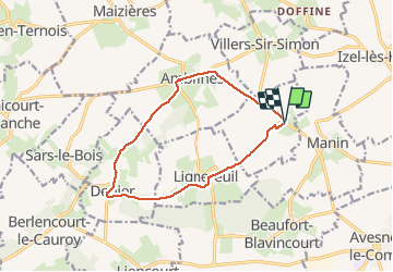
Tocht Stappen van 11 km beschikbaar op Hauts-de-France, Pas-de-Calais, Givenchy-le-Noble. Deze tocht wordt voorgesteld door tracegps.

Beschrijving

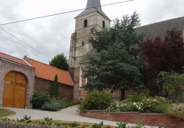
Belle randonnée au départ d'un château et qui emprunte une allée magnifique bordée d'une double rangée de tilleuls entre deux châteaux Lignereuil et Givenchy.

Hoogteprofiel

Foto's

POI's

POI Givenchy-le-Noble - WP 1 - Photo
tracegps
GIVENCHY-LE-NOBLE 
POI Givenchy-le-Noble - WP 2 - Photo
tracegps
GIVENCHY-LE-NOBLE 

Plaatsbepaling

Land:
France
Regio :
Hauts-de-France
Departement/Provincie :
Pas-de-Calais
Gemeente :
Givenchy-le-Noble
Locatie:
Unknown
Vertrek:(Dec)
Vertrek:(UTM)
464260 ; 5572227 (31U) N.

Wandeltochten in de omgeving

Tocht Mountainbike Avesnes-le-Comte - Les 6 châteaux - Avesnes le Comte - Photo
Mountainbike
tracegps

Mountainbike

Moeilijk
(1)
Avesnes-le-Comte, Hauts-de-France, Pas-de-Calais, France
44 km | 50 km-effort
2h 10min
Ja
Tocht Mountainbike Fosseux - Lucheux - Photo
Mountainbike
tracegps

Mountainbike

Medium
(2)
Fosseux, Hauts-de-France, Pas-de-Calais, France
44 km | 50 km-effort
3h 0min
Ja
Tocht Stappen Penin - Chemin des piedsentes  (Penin) - Photo
Stappen
tracegps

Stappen

Moeilijk
Penin, Hauts-de-France, Pas-de-Calais, France
14,5 km | 15,7 km-effort
3h 40min
Ja
Tocht Stappen Lignereuil - LIGNEREUIL (62) - Par le bois du Fay - Photo
Stappen
temmichel

Stappen

Moeilijk
Lignereuil, Hauts-de-France, Pas-de-Calais, France
12,1 km | 13,5 km-effort
3h 4min
Ja
Tocht Stappen Avesnes-le-Comte - Avesnes le Comte, Noyelle-Vion, Manin, Beaufort-Blavincourt - Photo
Stappen
tracegps

Stappen

Medium
Avesnes-le-Comte, Hauts-de-France, Pas-de-Calais, France
10,8 km | 12,2 km-effort
2h 30min
Ja
Tocht Stappen Lignereuil - Lignereuil Allée des tilleuls - Blavincourt - Denier - Photo
Stappen
tracegps

Stappen

Medium
Lignereuil, Hauts-de-France, Pas-de-Calais, France
11,2 km | 12,7 km-effort
2h 0min
Ja
Tocht Mountainbike Avesnes-le-Comte - Les six châteaux - Photo
Mountainbike
Gilbert62580

Mountainbike

Medium
Avesnes-le-Comte, Hauts-de-France, Pas-de-Calais, France
44 km | 50 km-effort
Onbekend
Ja
Tocht Stappen Averdoingt - Rando1402 - Photo
Stappen
Michael Pruvost

Stappen

Averdoingt, Hauts-de-France, Pas-de-Calais, France
12,1 km | 13 km-effort
2h 7min
Ja
Tocht Stappen Averdoingt - RANDO 2 - Photo
Stappen
Michael Pruvost

Stappen

Averdoingt, Hauts-de-France, Pas-de-Calais, France
10,3 km | 11,5 km-effort
1h 58min
Neen


Sluiten
Mijn abonnementen