


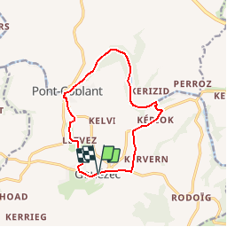
Circuit du pont Coblant - Gouézec

tracegps
Gebruiker


3h00
Moeilijkheid : Medium

Gratisgps-wandelapplicatie
 SityTrail
IGN / Geografische instituten
SityTrail Plus
De wereld gaat voor u open
Over ons
Tocht Stappen van 11,6 km beschikbaar op Bretagne, Finistère, Gouézec. Deze tocht wordt voorgesteld door tracegps.
Beschrijving
Circuit proposé par la Communauté de Communes de la région de Pleyben. Départ du parking de l’Eglise de Gouézec. Retrouvez le circuit sur le site de la communauté de communes de la région de Pleyben . Ce circuit a été numérisé par les randonneurs du CODEPEM. Merci à Jean-Marie.
Foto's


Plaatsbepaling
Opmerkingen