


Les 12 la s du Carlit ( Bouillouses ) 66

jpbearnais
Gebruiker
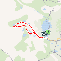

Lengte
10,6 km

Max. hoogte
2372 m

Positief hoogteverschil
369 m
Km-Effort
15,6 km

Min. hoogte
2002 m

Negatief hoogteverschil
395 m
Boucle
Neen
Datum van aanmaak :
2019-01-15 16:27:26.432
Laatste wijziging :
2019-01-15 16:27:26.432
2h47
Moeilijkheid : Onbekend

Gratisgps-wandelapplicatie
 SityTrail
IGN / Geografische instituten
SityTrail Plus
De wereld gaat voor u open
Over ons
Tocht Stappen van 10,6 km beschikbaar op Occitanië, Pyrénées-Orientales, Angoustrine-Villeneuve-des-Escaldes. Deze tocht wordt voorgesteld door jpbearnais.
Plaatsbepaling
Land:
France
Regio :
Occitanië
Departement/Provincie :
Pyrénées-Orientales
Gemeente :
Angoustrine-Villeneuve-des-Escaldes
Locatie:
Unknown
Vertrek:(Dec)
Vertrek:(UTM)
417716 ; 4712482 (31T) N.
Opmerkingen