


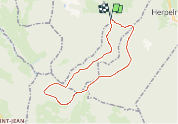
Espace VTT FFC Chemins du Coeur des Vosges - circuit n°50 - La grotte de l'Ermite

tracegps
Gebruiker


30m
Moeilijkheid : Medium

Gratisgps-wandelapplicatie
 SityTrail
IGN / Geografische instituten
SityTrail Plus
De wereld gaat voor u open
Over ons
Tocht Mountainbike van 7,6 km beschikbaar op Grand Est, Vogezen, Beauménil. Deze tocht wordt voorgesteld door tracegps.
Beschrijving
Espace VTT FFC Chemins du Cœur des Vosges - circuit n°50 - La grotte de l’Ermite. Circuit officiel labellisé par la Fédération Française de Cyclisme. Balade courte et facile dans la Forêt d’Herpelmont.
Foto's

Plaatsbepaling
Opmerkingen