


2018-10-11 Rando CVA Vosges Prof Ban De Laveline Taintrux

holtzv
Gebruiker GUIDE
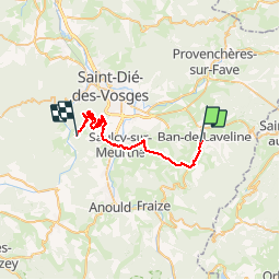

Lengte
28 km

Max. hoogte
694 m

Positief hoogteverschil
708 m
Km-Effort
37 km

Min. hoogte
378 m

Negatief hoogteverschil
747 m
Boucle
Neen
Datum van aanmaak :
2018-10-15 21:00:30.998
Laatste wijziging :
2018-10-16 11:08:25.681
4h33
Moeilijkheid : Gemakkelijk

Gratisgps-wandelapplicatie
 SityTrail
IGN / Geografische instituten
SityTrail Plus
De wereld gaat voor u open
Over ons
Tocht Paardrijden van 28 km beschikbaar op Grand Est, Vogezen, Ban-de-Laveline. Deze tocht wordt voorgesteld door holtzv.
Foto's

Plaatsbepaling
Land:
France
Regio :
Grand Est
Departement/Provincie :
Vogezen
Gemeente :
Ban-de-Laveline
Locatie:
Unknown
Vertrek:(Dec)
Vertrek:(UTM)
356093 ; 5344806 (32U) N.
Opmerkingen