


2018-10-10 Hondarribia - San Sebastian

Lucquiaud
Gebruiker
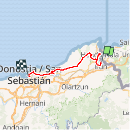

Lengte
33 km

Max. hoogte
286 m

Positief hoogteverschil
732 m
Km-Effort
43 km

Min. hoogte
-2 m

Negatief hoogteverschil
733 m
Boucle
Neen
Datum van aanmaak :
2019-01-15 17:31:55.029
Laatste wijziging :
2019-01-15 17:31:55.029
9h34
Moeilijkheid : Moeilijk

Gratisgps-wandelapplicatie
 SityTrail
IGN / Geografische instituten
SityTrail Plus
De wereld gaat voor u open
Over ons
Tocht Mountainbike van 33 km beschikbaar op Autonome Gemeenschap Baskenland, Gipuzkoa, Irun. Deze tocht wordt voorgesteld door Lucquiaud.
Plaatsbepaling
Land:
Spain
Regio :
Autonome Gemeenschap Baskenland
Departement/Provincie :
Gipuzkoa
Gemeente :
Irun
Locatie:
Unknown
Vertrek:(Dec)
Vertrek:(UTM)
598291 ; 4800113 (30T) N.
Opmerkingen