


Etape11- Conques-Livinhac-le-Haut

ghislainem
Gebruiker
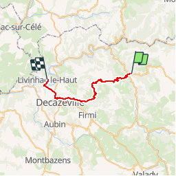

Lengte
27 km

Max. hoogte
583 m

Positief hoogteverschil
909 m
Km-Effort
39 km

Min. hoogte
177 m

Negatief hoogteverschil
989 m
Boucle
Neen
Datum van aanmaak :
2019-01-15 17:36:32.061
Laatste wijziging :
2019-01-15 17:36:32.061
8h06
Moeilijkheid : Onbekend

Gratisgps-wandelapplicatie
 SityTrail
IGN / Geografische instituten
SityTrail Plus
De wereld gaat voor u open
Over ons
Tocht Stappen van 27 km beschikbaar op Occitanië, Aveyron, Conques-en-Rouergue. Deze tocht wordt voorgesteld door ghislainem.
Plaatsbepaling
Land:
France
Regio :
Occitanië
Departement/Provincie :
Aveyron
Gemeente :
Conques-en-Rouergue
Locatie:
Unknown
Vertrek:(Dec)
Vertrek:(UTM)
452208 ; 4938634 (31T) N.
Opmerkingen