Tocht Fiets Clergoux - Massif des Monédières - le Suc au May - Photo

Massif des Monédières - le Suc au May

 tracegps
tracegps

Gebruiker

© OpenStreetMap contributors
Lengte
Lengte
70 km
Max. hoogte
Max. hoogte
906 m
Positief hoogteverschil
1484 m
Km-Effort
Km-Effort  
90 km
Min. hoogte
Min. hoogte
437 m
Negatief hoogteverschil
1482 m
Boucle
Boucle
Ja
Datum van aanmaak :
2014-12-10 00:00:00.0
Laatste wijziging :
2014-12-10 00:00:00.0

(0 Bericht)

Fiets
Fiets
3h30
Moeilijkheid : Moeilijk

Scan deze QR-code om de tocht te openen in de SityTrail-applicatie

Gratisgps-wandelapplicatie

Logo SityTrail SityTrail

IGN / Geografische instituten

SityTrail uit de App Store downloaden SityTrail uit Google Play downloaden

Logo SityTrail SityTrail World

De wereld gaat voor u open

SityTrail uit de App Store downloaden SityTrail uit Google Play downloaden SityTrail op Huawei AppGallery downloaden

Over ons

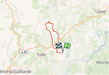
Tocht Fiets van 70 km beschikbaar op Nieuw-Aquitanië, Corrèze, Clergoux. Deze tocht wordt voorgesteld door tracegps.

Beschrijving

Direct Chaumeil par Barbazange, montée directe Suc au May

Hoogteprofiel

Foto's

Plaatsbepaling

Land:
France
Regio :
Nieuw-Aquitanië
Departement/Provincie :
Corrèze
Gemeente :
Clergoux
Locatie:
Unknown
Vertrek:(Dec)
Vertrek:(UTM)
419197 ; 5014872 (31T) N.

Wandeltochten in de omgeving

Tocht Stappen Eyrein - Etang de la chéze - Photo
Stappen
gerard1222

Stappen

Gemakkelijk
(1)
Eyrein, Nieuw-Aquitanië, Corrèze, France
4 km | 4,9 km-effort
1h 7min
Ja
Tocht Stappen Clergoux - 49 TraceGps issued - Photo
Stappen
houbart

Stappen

Moeilijk
Clergoux, Nieuw-Aquitanië, Corrèze, France
14,2 km | 17,2 km-effort
3h 53min
Ja
Tocht Stappen Clergoux - balade avec Claudette et Viviane  - Photo
Stappen
Nicole Cridel

Stappen

Heel gemakkelijk
Clergoux, Nieuw-Aquitanië, Corrèze, France
4,9 km | 6 km-effort
1h 41min
Ja
Tocht Paard Clergoux - Le grand tour de Sédières - Clergoux - Pays de Tulle  - Photo
Paard
tracegps

Paard

Medium
(1)
Clergoux, Nieuw-Aquitanië, Corrèze, France
14,2 km | 17,2 km-effort
2h 30min
Ja
Tocht Mountainbike Clergoux - Le grand tour de Sédières - Clergoux - Pays de Tulle  - Photo
Mountainbike
tracegps

Mountainbike

Medium
Clergoux, Nieuw-Aquitanië, Corrèze, France
14,2 km | 17,2 km-effort
1h 10min
Ja
Tocht Stappen Clergoux - Le grand tour de Sédières - Clergoux - Pays de Tulle  - Photo
Stappen
tracegps

Stappen

Medium
Clergoux, Nieuw-Aquitanië, Corrèze, France
14,2 km | 17,2 km-effort
4h 0min
Ja
Tocht Mountainbike Champagnac-la-Noaille - Combrignac - Champagnac la Noaille - Pays d'Égletons - Photo
Mountainbike
tracegps

Mountainbike

Medium
Champagnac-la-Noaille, Nieuw-Aquitanië, Corrèze, France
6,1 km | 8,4 km-effort
30min
Ja
Tocht Stappen Champagnac-la-Noaille - Combrignac - Champagnac la Noaille - Pays d'Égletons - Photo
Stappen
tracegps

Stappen

Medium
Champagnac-la-Noaille, Nieuw-Aquitanië, Corrèze, France
6,1 km | 8,4 km-effort
1h 30min
Ja
Tocht Stappen Clergoux - Clergoux Les vieilles pierres - Photo
Stappen
grageot

Stappen

Medium
Clergoux, Nieuw-Aquitanië, Corrèze, France
8,6 km | 10,4 km-effort
2h 21min
Ja


Sluiten
Mijn abonnementen