


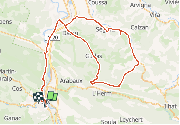
Col de Py dans le Massif du Plantaurel - Foix

tracegps
Gebruiker

Lengte
57 km

Max. hoogte
578 m

Positief hoogteverschil
668 m
Km-Effort
65 km

Min. hoogte
336 m

Negatief hoogteverschil
668 m
Boucle
Ja
Datum van aanmaak :
2014-12-10 00:00:00.0
Laatste wijziging :
2014-12-10 00:00:00.0
2h30
Moeilijkheid : Medium

Gratisgps-wandelapplicatie
 SityTrail
IGN / Geografische instituten
SityTrail Plus
De wereld gaat voor u open
Over ons
Tocht Fiets van 57 km beschikbaar op Occitanië, Ariège, Foix. Deze tocht wordt voorgesteld door tracegps.
Beschrijving
C'est un circuit tout en douceur qui s'effectue sur des routes tranquilles jusqu'au point culminant, le col de PY.
Plaatsbepaling
Land:
France
Regio :
Occitanië
Departement/Provincie :
Ariège
Gemeente :
Foix
Locatie:
Unknown
Vertrek:(Dec)
Vertrek:(UTM)
386503 ; 4757057 (31T) N.
Opmerkingen