Tocht Stappen Bozouls - De Barriac à Rodelle - Photo

De Barriac à Rodelle

 tracegps
tracegps

Gebruiker

© OpenStreetMap contributors
Lengte
Lengte
12,3 km
Max. hoogte
Max. hoogte
598 m
Positief hoogteverschil
314 m
Km-Effort
Km-Effort  
16,5 km
Min. hoogte
Min. hoogte
359 m
Negatief hoogteverschil
312 m
Boucle
Boucle
Ja
Datum van aanmaak :
2014-12-10 00:00:00.0
Laatste wijziging :
2014-12-10 00:00:00.0

(0 Bericht)

Stappen
Stappen
3h15
Moeilijkheid : Medium

Scan deze QR-code om de tocht te openen in de SityTrail-applicatie

Gratisgps-wandelapplicatie

Logo SityTrail SityTrail

IGN / Geografische instituten

SityTrail uit de App Store downloaden SityTrail uit Google Play downloaden

Logo SityTrail SityTrail World

De wereld gaat voor u open

SityTrail uit de App Store downloaden SityTrail uit Google Play downloaden SityTrail op Huawei AppGallery downloaden

Over ons

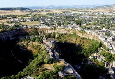
Tocht Stappen van 12,3 km beschikbaar op Occitanië, Aveyron, Bozouls. Deze tocht wordt voorgesteld door tracegps.

Beschrijving

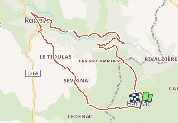
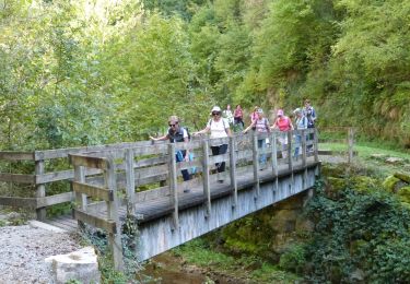
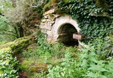
Pour cette jolie promenade, le départ se fait normalement à Barriac. Vous pouvez vous garer à côté de l'église ou mieux prenez la rue qui part en face de la porte de l'église sur 100 m et la rue en voie sans issue où il y a beaucoup plus d'espace pour se garer. Deuxième départ possible,Rodelle. Vous avez un grand parking à l'entrée du village, Rodelle qui est un site classé, joli village à visiter. Vous avez aussi a 1 km du parking en prenant la direction de Villecomtal la grotte de Sainte Tarcisse lieu de culte. En ce qui concerne la randonnée, elle ne présente aucune difficulté, balisée en jaune, très agréable je la fais tous les ans. Quant à la durée ? Tout seul en prenant mon temps je mets environ 2:45 minutes sur le topo guide il la donne en 4:30!!!! Je pense qu'ils doivent s'arrêter à l'auberge à Rodelle pour casser la croûte !!! Bonne balade à tous.

Hoogteprofiel

Foto's

Plaatsbepaling

Land:
France
Regio :
Occitanië
Departement/Provincie :
Aveyron
Gemeente :
Bozouls
Locatie:
Unknown
Vertrek:(Dec)
Vertrek:(UTM)
473157 ; 4923980 (31T) N.

Wandeltochten in de omgeving

Tocht Te voet Sébazac-Concourès - Circuit 17 Concourès - Photo
Te voet
PRO

Te voet

Gemakkelijk
Sébazac-Concourès, Occitanië, Aveyron, France
9 km | 10,6 km-effort
2h 24min
Ja
Tocht Stappen Rodelle - BEZONNES Nord - Photo
Stappen
Strabidja

Stappen

Medium
(1)
Rodelle, Occitanië, Aveyron, France
6 km | 6,3 km-effort
1h 25min
Ja
Tocht Stappen Bozouls - Trou de Bozouls - Photo
Stappen
jmpu

Stappen

Gemakkelijk
(4)
Bozouls, Occitanië, Aveyron, France
14,5 km | 19,9 km-effort
4h 15min
Ja
Tocht Mountainbike Rodelle - Ledenac 2 - Photo
Mountainbike
bonnetchristian

Mountainbike

Heel gemakkelijk
(1)
Rodelle, Occitanië, Aveyron, France
5,5 km | 6,8 km-effort
Onbekend
Neen
Tocht Te voet Bozouls - De Bozouls à Rodelle - Photo
Te voet
PRO

Te voet

Gemakkelijk
Bozouls, Occitanië, Aveyron, France
10,4 km | 13,6 km-effort
3h 4min
Neen
Tocht Stappen Bozouls - Bozoul (Après-midi) - Photo
Stappen
jesusmarieclaire

Stappen

Gemakkelijk
Bozouls, Occitanië, Aveyron, France
4,8 km | 6,6 km-effort
2h 0min
Ja
Tocht Te voet Bozouls - BARRIAC / CARCUAC - Photo
Te voet
Strabidja

Te voet

Gemakkelijk
Bozouls, Occitanië, Aveyron, France
3,9 km | 4,8 km-effort
1h 0min
Ja
Tocht Stappen Bozouls - Le site géologique de Bozouls - Photo
Stappen
GUIDE
jagarnier

Stappen

Medium
(1)
Bozouls, Occitanië, Aveyron, France
15,7 km | 21 km-effort
4h 45min
Ja
Tocht Stappen Bozouls - Circuit des passerelles à Bozouls - Photo
Stappen
GUIDE
jagarnier

Stappen

Medium
Bozouls, Occitanië, Aveyron, France
11,6 km | 16,3 km-effort
3h 30min
Ja


Sluiten
Mijn abonnementen