


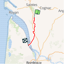
2018-10-05 Pons - Lamarque

Lucquiaud
Gebruiker

Lengte
70 km

Max. hoogte
97 m

Positief hoogteverschil
564 m
Km-Effort
78 km

Min. hoogte
-4 m

Negatief hoogteverschil
604 m
Boucle
Neen
Datum van aanmaak :
2019-01-15 18:14:28.147
Laatste wijziging :
2019-01-15 18:14:28.147
8h01
Moeilijkheid : Gemakkelijk

Gratisgps-wandelapplicatie
 SityTrail
IGN / Geografische instituten
SityTrail Plus
De wereld gaat voor u open
Over ons
Tocht Mountainbike van 70 km beschikbaar op Nieuw-Aquitanië, Charente-Maritime, Saint-Quantin-de-Rançanne. Deze tocht wordt voorgesteld door Lucquiaud.
Plaatsbepaling
Land:
France
Regio :
Nieuw-Aquitanië
Departement/Provincie :
Charente-Maritime
Gemeente :
Saint-Quantin-de-Rançanne
Locatie:
Unknown
Vertrek:(Dec)
Vertrek:(UTM)
689465 ; 5045685 (30T) N.
Opmerkingen