Tocht Fiets Foix - Col des Marous par les Col Legrillou et Uscla - Photo

Col des Marous par les Col Legrillou et Uscla

 tracegps
tracegps

Gebruiker

© OpenStreetMap contributors
Lengte
Lengte
55 km
Max. hoogte
Max. hoogte
1317 m
Positief hoogteverschil
1232 m
Km-Effort
Km-Effort  
72 km
Min. hoogte
Min. hoogte
389 m
Negatief hoogteverschil
1233 m
Boucle
Boucle
Ja
Datum van aanmaak :
2014-12-10 00:00:00.0
Laatste wijziging :
2014-12-10 00:00:00.0

(0 Bericht)

Fiets
Fiets
2h00
Moeilijkheid : Moeilijk

Scan deze QR-code om de tocht te openen in de SityTrail-applicatie

Gratisgps-wandelapplicatie

Logo SityTrail SityTrail

IGN / Geografische instituten

SityTrail uit de App Store downloaden SityTrail uit Google Play downloaden

Logo SityTrail SityTrail Plus

De wereld gaat voor u open

SityTrail uit de App Store downloaden SityTrail uit Google Play downloaden SityTrail op Huawei AppGallery downloaden

Over ons

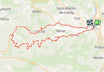
Tocht Fiets van 55 km beschikbaar op Occitanië, Ariège, Foix. Deze tocht wordt voorgesteld door tracegps.

Beschrijving

Circuit agréable, difficulté moyenne jusqu'au col Legrillou, puis plat montant en milieu forestier, très agréable par temps chaud. En redescendant sur Foix on peut au col des Marous redescendre par la Bastide de Sérou et revenir par Alzun. Prévoir une bonne heure de plus.

Hoogteprofiel

Plaatsbepaling

Land:
France
Regio :
Occitanië
Departement/Provincie :
Ariège
Gemeente :
Foix
Locatie:
Unknown
Vertrek:(Dec)
Vertrek:(UTM)
386499 ; 4757052 (31T) N.


Sluiten
Mijn abonnementen