


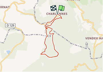
Espace VTT FFC du Sancy - Circuit n°16 - Le Buron - Secteur La Bourboule

tracegps
Gebruiker


30m
Moeilijkheid : Medium

Gratisgps-wandelapplicatie
 SityTrail
IGN / Geografische instituten
SityTrail Plus
De wereld gaat voor u open
Over ons
Tocht Mountainbike van 6,4 km beschikbaar op Auvergne-Rhône-Alpes, Puy-de-Dôme, La Bourboule. Deze tocht wordt voorgesteld door tracegps.
Beschrijving
Espace VTT FFC du Sancy - Circuit n°16 - Le Buron - Secteur La Bourboule Circuit officiel labellisé par la Fédération Française de Cyclisme. Départ du plateau de Charlannes. Ce site domine la fameuse ville d’eaux, offre un grand bol d’oxygène avec des circuits de difficulté variées, sur un sol un peu agressif et en sous-bois.
Foto's


Plaatsbepaling
Opmerkingen