Tocht Stappen Prévinquières - De Prévinquières à Mirabel - Photo

De Prévinquières à Mirabel

 tracegps
tracegps

Gebruiker

© OpenStreetMap contributors
Lengte
Lengte
10,7 km
Max. hoogte
Max. hoogte
571 m
Positief hoogteverschil
338 m
Km-Effort
Km-Effort  
15,2 km
Min. hoogte
Min. hoogte
379 m
Negatief hoogteverschil
342 m
Boucle
Boucle
Ja
Datum van aanmaak :
2014-12-10 00:00:00.0
Laatste wijziging :
2014-12-10 00:00:00.0

(1 Bericht)

Stappen
Stappen
3h00
Moeilijkheid : Medium

Scan deze QR-code om de tocht te openen in de SityTrail-applicatie

Gratisgps-wandelapplicatie

Logo SityTrail SityTrail

IGN / Geografische instituten

SityTrail uit de App Store downloaden SityTrail uit Google Play downloaden

Logo SityTrail SityTrail World

De wereld gaat voor u open

SityTrail uit de App Store downloaden SityTrail uit Google Play downloaden SityTrail op Huawei AppGallery downloaden

Over ons

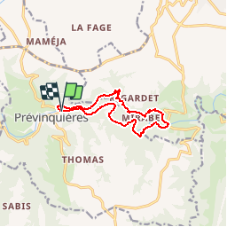
Tocht Stappen van 10,7 km beschikbaar op Occitanië, Aveyron, Prévinquières. Deze tocht wordt voorgesteld door tracegps.

Beschrijving

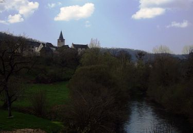
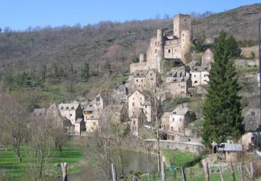
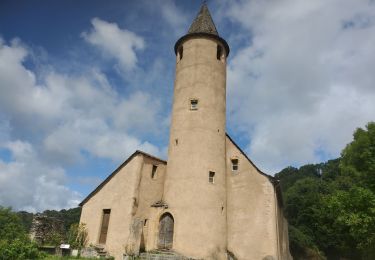
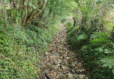
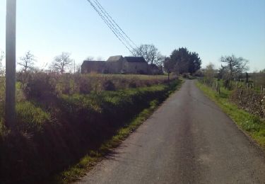
Cette randonnée au départ du pont de Prévinquière est une petite balade sans difficulté particulière parfaitement balisée en jaune, et agrémentée de nombreux aménagements, tables de pique-nique etc. Le départ de la randonnée s'effectue sur un joli petit sentier qui prend rapidement de la hauteur jusqu'à Mirabel pour redescendre ensuite au pont Mirabel que vous traversez. Puis vous regagnez le point de départ par une large piste qui longe l'Aveyron. Promenade très reposante. Bonne balade à tous.

Hoogteprofiel

Foto's

Plaatsbepaling

Land:
France
Regio :
Occitanië
Departement/Provincie :
Aveyron
Gemeente :
Prévinquières
Locatie:
Unknown
Vertrek:(Dec)
Vertrek:(UTM)
438951 ; 4913865 (31T) N.

Opmerkingen

Gelieve in te loggen om een commentaar of een beoordeling achter te laten


Wandeltochten in de omgeving

Tocht Te voet Prévinquières - Sentier des Puechs - Photo
Te voet
PRO

Te voet

Gemakkelijk
Prévinquières, Occitanië, Aveyron, France
8,7 km | 13 km-effort
2h 56min
Ja
Tocht Te voet Prévinquières - Sentier Pervenche 2 - Photo
Te voet
PRO

Te voet

Gemakkelijk
Prévinquières, Occitanië, Aveyron, France
7,5 km | 10,8 km-effort
2h 27min
Ja
Tocht Te voet Prévinquières - Sentier du Maquis - Photo
Te voet
PRO

Te voet

Gemakkelijk
Prévinquières, Occitanië, Aveyron, France
11 km | 15,5 km-effort
3h 31min
Ja
Tocht Te voet Prévinquières - Sentier «Pervenche 1» - Photo
Te voet
PRO

Te voet

Gemakkelijk
Prévinquières, Occitanië, Aveyron, France
5,1 km | 7,5 km-effort
1h 42min
Ja
Tocht Fiets Rignac - Circuit de Rignac - Marcillac - Photo
Fiets
tracegps

Fiets

Moeilijk
Rignac, Occitanië, Aveyron, France
63 km | 82 km-effort
4h 30min
Ja
Tocht Te voet Rignac - Sentier Ethno-Botanique en Ségala - Photo
Te voet
PRO

Te voet

Gemakkelijk
Rignac, Occitanië, Aveyron, France
7,2 km | 10,5 km-effort
2h 23min
Ja
Tocht Elektrische fiets Prévinquières - tour de mirabel - Photo
Elektrische fiets
jdaviere

Elektrische fiets

Moeilijk
Prévinquières, Occitanië, Aveyron, France
15,2 km | 22 km-effort
1h 20min
Ja
Tocht Elektrische fiets Prévinquières - previnquieres rieupeyroux - Photo
Elektrische fiets
jdaviere

Elektrische fiets

Moeilijk
Prévinquières, Occitanië, Aveyron, France
23 km | 31 km-effort
1h 43min
Ja
Tocht Stappen Rignac - maquis de guesclins rignac - Photo
Stappen
lascap12

Stappen

Medium
(1)
Rignac, Occitanië, Aveyron, France
14,8 km | 21 km-effort
4h 11min
Ja


Sluiten
Mijn abonnementen