


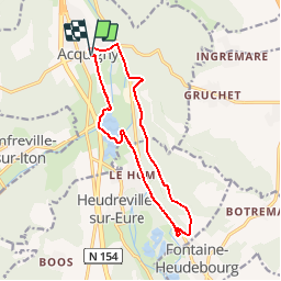
Circuit des étangs Acquigny

randojj
Gebruiker

Lengte
12,3 km

Max. hoogte
144 m

Positief hoogteverschil
182 m
Km-Effort
14,8 km

Min. hoogte
14 m

Negatief hoogteverschil
182 m
Boucle
Ja
Datum van aanmaak :
2019-04-26 07:45:15.696
Laatste wijziging :
2019-04-26 07:45:15.72
3h12
Moeilijkheid : Medium

Gratisgps-wandelapplicatie
 SityTrail
IGN / Geografische instituten
SityTrail Plus
De wereld gaat voor u open
Over ons
Tocht Stappen van 12,3 km beschikbaar op Normandië, Eure, Acquigny. Deze tocht wordt voorgesteld door randojj.
Beschrijving
Départ ancienne gare d'Acquigny. coordonnées GPS Latitude 49.1720806 Longitude 1.1796355.
Plaatsbepaling
Land:
France
Regio :
Normandië
Departement/Provincie :
Eure
Gemeente :
Acquigny
Locatie:
Unknown
Vertrek:(Dec)
Vertrek:(UTM)
367324 ; 5448158 (31U) N.
Opmerkingen