


stanneux nord 12 18

Mullender
Gebruiker
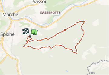

Lengte
8,4 km

Max. hoogte
373 m

Positief hoogteverschil
193 m
Km-Effort
11 km

Min. hoogte
282 m

Negatief hoogteverschil
195 m
Boucle
Ja
Datum van aanmaak :
2019-01-15 20:03:44.465
Laatste wijziging :
2019-01-15 20:03:44.465
1h50
Moeilijkheid : Medium

Gratisgps-wandelapplicatie
 SityTrail
IGN / Geografische instituten
SityTrail Plus
De wereld gaat voor u open
Over ons
Tocht Stappen van 8,4 km beschikbaar op Wallonië, Luik, Theux. Deze tocht wordt voorgesteld door Mullender.
Foto's

Plaatsbepaling
Land:
Belgium
Regio :
Wallonië
Departement/Provincie :
Luik
Gemeente :
Theux
Locatie:
Theux
Vertrek:(Dec)
Vertrek:(UTM)
700740 ; 5600192 (31U) N.
Opmerkingen