


Plan d Aups Source de l'Huveaune bis

ARPF1
Gebruiker
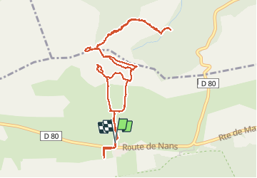

Lengte
6,3 km

Max. hoogte
775 m

Positief hoogteverschil
430 m
Km-Effort
12,1 km

Min. hoogte
476 m

Negatief hoogteverschil
428 m
Boucle
Ja
Datum van aanmaak :
2019-05-06 11:37:54.964
Laatste wijziging :
2019-05-06 11:37:54.964
3h07
Moeilijkheid : Moeilijk

Gratisgps-wandelapplicatie
 SityTrail
IGN / Geografische instituten
SityTrail Plus
De wereld gaat voor u open
Over ons
Tocht Stappen van 6,3 km beschikbaar op Provence-Alpes-Côte d'Azur, Var, Plan-d'Aups-Sainte-Baume. Deze tocht wordt voorgesteld door ARPF1.


Plaatsbepaling
Land:
France
Regio :
Provence-Alpes-Côte d'Azur
Departement/Provincie :
Var
Gemeente :
Plan-d'Aups-Sainte-Baume
Locatie:
Unknown
Vertrek:(Dec)
Vertrek:(UTM)
723423 ; 4801836 (31T) N.
Opmerkingen