Tocht Fiets Casteljaloux - Circuit des Cadets de Gascogne - Casteljaloux - Photo

Circuit des Cadets de Gascogne - Casteljaloux

 tracegps
tracegps

Gebruiker

© OpenStreetMap contributors
Lengte
Lengte
86 km
Max. hoogte
Max. hoogte
173 m
Positief hoogteverschil
1264 m
Km-Effort
Km-Effort  
103 km
Min. hoogte
Min. hoogte
42 m
Negatief hoogteverschil
1264 m
Boucle
Boucle
Ja
Datum van aanmaak :
2014-12-10 00:00:00.0
Laatste wijziging :
2014-12-10 00:00:00.0

(0 Bericht)

Fiets
Fiets
4h30
Moeilijkheid : Medium

Scan deze QR-code om de tocht te openen in de SityTrail-applicatie

Gratisgps-wandelapplicatie

Logo SityTrail SityTrail

IGN / Geografische instituten

SityTrail uit de App Store downloaden SityTrail uit Google Play downloaden

Logo SityTrail SityTrail World

De wereld gaat voor u open

SityTrail uit de App Store downloaden SityTrail uit Google Play downloaden SityTrail op Huawei AppGallery downloaden

Over ons

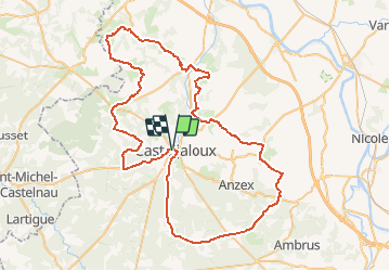
Tocht Fiets van 86 km beschikbaar op Nieuw-Aquitanië, Lot-et-Garonne, Casteljaloux. Deze tocht wordt voorgesteld door tracegps.

Beschrijving

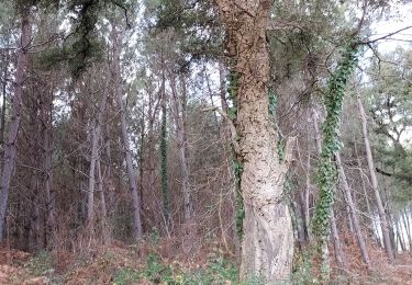
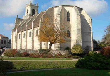
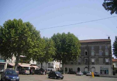
Circuit des Cadets de Gascogne Casteljaloux, porte de la forêt des Landes de Gascogne, est un départ de choix pour cette balade qui commence et se termine dans la forêt, attaque les reliefs plus accidentés des coteaux sud du Marmandais. S'ouvrent alors de larges panoramas sur les Landes, la vallée de la Garonne et les collines de la capitale de la tomate. Outre la nature, vous observerez sur le parcours de nombreuses églises classées et quelques châteaux remarquables. Téléchargez la fiche de cette randonnée sur le site du Tourisme du Lot et Garonne.

Hoogteprofiel

Foto's

Plaatsbepaling

Land:
France
Regio :
Nieuw-Aquitanië
Departement/Provincie :
Lot-et-Garonne
Gemeente :
Casteljaloux
Locatie:
Unknown
Vertrek:(Dec)
Vertrek:(UTM)
267576 ; 4910882 (31T) N.

Wandeltochten in de omgeving

Tocht Te voet Beauziac - Beauziac, balade vers l'église du Tren - 6.7 km - Photo
Te voet
PRO

Te voet

Gemakkelijk
Beauziac, Nieuw-Aquitanië, Lot-et-Garonne, France
6,5 km | 7,7 km-effort
1h 44min
Ja
Tocht Te voet Labastide-Castel-Amouroux - Labastide-Castel-Amouroux vers l’Église de Saint-Gény - 5.1 km - Photo
Te voet
PRO

Te voet

Gemakkelijk
Labastide-Castel-Amouroux, Nieuw-Aquitanië, Lot-et-Garonne, France
4,6 km | 5,9 km-effort
1h 20min
Ja
Tocht Te voet Labastide-Castel-Amouroux - Labastide-Castel-Amouroux à ciel ouvert - 17.7 km - Photo
Te voet
PRO

Te voet

Medium
Labastide-Castel-Amouroux, Nieuw-Aquitanië, Lot-et-Garonne, France
17,6 km | 22 km-effort
5h 3min
Ja
Tocht Te voet Pompogne - La Réunion - La Taillade, vacances dans les bois de la Réunion - 3.4 km - Photo
Te voet
PRO

Te voet

Gemakkelijk
Pompogne, Nieuw-Aquitanië, Lot-et-Garonne, France
3 km | 3,3 km-effort
45min
Ja
Tocht Te voet La Réunion - La Réunion - La Taillade, par les églises de Beyrac et Couthures - 21.3 km - Photo
Te voet
PRO

Te voet

Medium
La Réunion, Nieuw-Aquitanië, Lot-et-Garonne, France
21 km | 25 km-effort
5h 46min
Ja
Tocht Stappen Beauziac - beauziac - Photo
Stappen
christiane01

Stappen

Gemakkelijk
Beauziac, Nieuw-Aquitanië, Lot-et-Garonne, France
6,7 km | 7,8 km-effort
2h 21min
Ja
Tocht Mountainbike Casteljaloux - Casteljaloux, porte de la forêt landaise - Pays Val de Garonne - Gascogne - Photo
Mountainbike
tracegps

Mountainbike

Medium
Casteljaloux, Nieuw-Aquitanië, Lot-et-Garonne, France
9,2 km | 11,1 km-effort
1h 15min
Ja
Tocht Stappen Casteljaloux - Casteljaloux, porte de la forêt landaise - Pays Val de Garonne - Gascogne - Photo
Stappen
tracegps

Stappen

Medium
Casteljaloux, Nieuw-Aquitanië, Lot-et-Garonne, France
9,2 km | 11,1 km-effort
3h 0min
Ja
Tocht Mountainbike Casteljaloux - Casteljaloux, au pays des Cadets de Gascogne - Pays Val de Garonne - Gascogne - Photo
Mountainbike
tracegps

Mountainbike

Moeilijk
Casteljaloux, Nieuw-Aquitanië, Lot-et-Garonne, France
17,5 km | 20 km-effort
2h 15min
Ja


Sluiten
Mijn abonnementen