


Gimel les cascades

houbart
Gebruiker
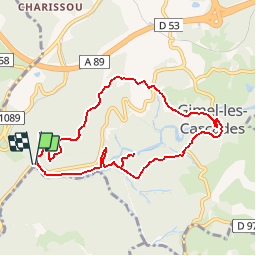

Lengte
8,9 km

Max. hoogte
460 m

Positief hoogteverschil
311 m
Km-Effort
13,1 km

Min. hoogte
284 m

Negatief hoogteverschil
312 m
Boucle
Ja
Datum van aanmaak :
2019-03-28 15:46:58.824
Laatste wijziging :
2019-03-28 15:46:58.824
2h45
Moeilijkheid : Onbekend

Gratisgps-wandelapplicatie
 SityTrail
IGN / Geografische instituten
SityTrail Plus
De wereld gaat voor u open
Over ons
Tocht Stappen van 8,9 km beschikbaar op Nieuw-Aquitanië, Corrèze, Gimel-les-Cascades. Deze tocht wordt voorgesteld door houbart.
Plaatsbepaling
Land:
France
Regio :
Nieuw-Aquitanië
Departement/Provincie :
Corrèze
Gemeente :
Gimel-les-Cascades
Locatie:
Unknown
Vertrek:(Dec)
Vertrek:(UTM)
407504 ; 5016321 (31T) N.
Opmerkingen