


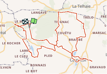
23/03/2019.Corrigé - CARENTOIR nord-ouest

babeth35
Gebruiker

Lengte
31 km

Max. hoogte
115 m

Positief hoogteverschil
486 m
Km-Effort
38 km

Min. hoogte
27 m

Negatief hoogteverschil
496 m
Boucle
Ja
Datum van aanmaak :
2019-03-29 13:29:29.238
Laatste wijziging :
2020-07-20 14:58:50.247
8h11
Moeilijkheid : Medium

Gratisgps-wandelapplicatie
 SityTrail
IGN / Geografische instituten
SityTrail Plus
De wereld gaat voor u open
Over ons
Tocht Stappen van 31 km beschikbaar op Bretagne, Morbihan, Carentoir. Deze tocht wordt voorgesteld door babeth35.
Foto's


Plaatsbepaling
Land:
France
Regio :
Bretagne
Departement/Provincie :
Morbihan
Gemeente :
Carentoir
Locatie:
Carentoir
Vertrek:(Dec)
Vertrek:(UTM)
560549 ; 5299067 (30T) N.
Opmerkingen