Tocht Stappen Saint-Léger-sur-Dheune - Circuit n°1 de Saint Leger sur Dheune - Photo
 tracegps
tracegps

Gebruiker

© OpenStreetMap contributors
Lengte
Lengte
8 km
Max. hoogte
Max. hoogte
386 m
Positief hoogteverschil
169 m
Km-Effort
Km-Effort  
10,2 km
Min. hoogte
Min. hoogte
232 m
Negatief hoogteverschil
168 m
Boucle
Boucle
Ja
Datum van aanmaak :
2014-12-10 00:00:00.0
Laatste wijziging :
2014-12-10 00:00:00.0

(0 Bericht)

Stappen
Stappen
2h00
Moeilijkheid : Gemakkelijk

Scan deze QR-code om de tocht te openen in de SityTrail-applicatie

Gratisgps-wandelapplicatie

Logo SityTrail SityTrail

IGN / Geografische instituten

SityTrail uit de App Store downloaden SityTrail uit Google Play downloaden

Logo SityTrail SityTrail World

De wereld gaat voor u open

SityTrail uit de App Store downloaden SityTrail uit Google Play downloaden SityTrail op Huawei AppGallery downloaden

Over ons

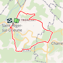
Tocht Stappen van 8 km beschikbaar op Bourgondië-Franche-Comté, Saône-et-Loire, Saint-Léger-sur-Dheune. Deze tocht wordt voorgesteld door tracegps.

Beschrijving

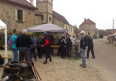
Circuit proposé par la commune de Saint Leger sur Dheune et l'association des amis de Saint Leger sur Dheune . Départ de la place du marché à Saint-Leger-sur-Dheune. Retrouvez le circuit et son descriptif sur le site de la commune de Saint Leger sur Dheune (Onglet « Activités touristiques »).

Hoogteprofiel

Foto's

Plaatsbepaling

Land:
France
Regio :
Bourgondië-Franche-Comté
Departement/Provincie :
Saône-et-Loire
Gemeente :
Saint-Léger-sur-Dheune
Locatie:
Unknown
Vertrek:(Dec)
Vertrek:(UTM)
624693 ; 5189432 (31T) N.

Wandeltochten in de omgeving

Tocht Stappen Saint-Maurice-lès-Couches - Saint Maurice les Couches  GRS (gde) - Photo
Stappen
Malice0093

Stappen

Moeilijk
(1)
Saint-Maurice-lès-Couches, Bourgondië-Franche-Comté, Saône-et-Loire, France
11,5 km | 15,3 km-effort
3h 29min
Ja
Tocht Stappen Charrecey - Charrecey Le Montabon  page 29 - Photo
Stappen
grasgilbert

Stappen

Moeilijk
(2)
Charrecey, Bourgondië-Franche-Comté, Saône-et-Loire, France
12,9 km | 18 km-effort
3h 59min
Ja
Tocht Te voet Saint-Jean-de-Trézy - Saint Jean de Trézy - Photo
Te voet
Malice0093

Te voet

Gemakkelijk
(1)
Saint-Jean-de-Trézy, Bourgondië-Franche-Comté, Saône-et-Loire, France
11,3 km | 13,9 km-effort
3h 8min
Ja
Tocht Stappen Couches - couches saint jean de trézy - Photo
Stappen
patourad

Stappen

Gemakkelijk
(1)
Couches, Bourgondië-Franche-Comté, Saône-et-Loire, France
11 km | 14,4 km-effort
3h 3min
Ja
Tocht Mountainbike Dennevy - Bourges (18) - Breurey lès Faverney (70) - Etape 4/6 - De Dennevy à Echigey - Photo
Mountainbike
tracegps

Mountainbike

Medium
Dennevy, Bourgondië-Franche-Comté, Saône-et-Loire, France
80 km | 88 km-effort
6h 0min
Neen
Tocht Te voet Dracy-lès-Couches - Les Balcons de Dracy - Photo
Te voet
PRO

Te voet

Gemakkelijk
Dracy-lès-Couches, Bourgondië-Franche-Comté, Saône-et-Loire, France
7,4 km | 9,2 km-effort
2h 5min
Ja
Tocht Stappen Saint-Maurice-lès-Couches - 20190418 Saint Maurice les couches fait - Photo
Stappen
sami55

Stappen

Heel gemakkelijk
Saint-Maurice-lès-Couches, Bourgondië-Franche-Comté, Saône-et-Loire, France
14,1 km | 18,5 km-effort
3h 46min
Ja
Tocht Mountainbike Couches - La Couchoise 2013  - Photo
Mountainbike
tofp21

Mountainbike

Medium
Couches, Bourgondië-Franche-Comté, Saône-et-Loire, France
33 km | 43 km-effort
2h 54min
Ja
Tocht Mountainbike Couches - La Couchoise 2009 - Photo
Mountainbike
tracegps

Mountainbike

Moeilijk
Couches, Bourgondië-Franche-Comté, Saône-et-Loire, France
42 km | 55 km-effort
4h 0min
Ja


Sluiten
Mijn abonnementen