Tocht Stappen Abbeville - LP80_ABBEVILLE_Ronde-de-l'eau_8.5km - Photo

LP80_ABBEVILLE_Ronde-de-l'eau_8.5km

Autour de la Baie à pieds
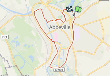
© OpenStreetMap contributors
Lengte
Lengte
8,5 km
Max. hoogte
Max. hoogte
21 m
Positief hoogteverschil
41 m
Km-Effort
Km-Effort  
9 km
Min. hoogte
Min. hoogte
3 m
Negatief hoogteverschil
43 m
Boucle
Boucle
Ja
Datum van aanmaak :
2019-04-01 21:50:57.616
Laatste wijziging :
2023-10-03 18:52:50.354

(0 Bericht)

Stappen
Stappen
2h01
Moeilijkheid : Medium

Scan deze QR-code om de tocht te openen in de SityTrail-applicatie

Gratisgps-wandelapplicatie

Logo SityTrail SityTrail

IGN / Geografische instituten

SityTrail uit de App Store downloaden SityTrail uit Google Play downloaden

Logo SityTrail SityTrail Plus

De wereld gaat voor u open

SityTrail uit de App Store downloaden SityTrail uit Google Play downloaden SityTrail op Huawei AppGallery downloaden

Over ons

Tocht Stappen van 8,5 km beschikbaar op Hauts-de-France, Somme, Abbeville. Deze tocht wordt voorgesteld door BAIE de SOMME & alentours.

Beschrijving

Une boucle autour
d’un fleuve, de rivières,
de rus, d’étangs et de
marais... un rappel que
l’eau est reine dans la
capitale du Ponthieu !
Départ : Kiosque, à côté de la piscine d’Abbeville.
AUTEUR  TRACE GPS.com
http://www.tracegps.com/fr/parcours/circuit1485.htm#

Fiche N°1 à l'Office du tourisme d'Abbeville.

Ce circuit est entretenu
par la ville d’Abbeville.

Hoogteprofiel

Foto's

Plaatsbepaling

Land:
France
Regio :
Hauts-de-France
Departement/Provincie :
Somme
Gemeente :
Abbeville
Locatie:
Unknown
Vertrek:(Dec)
Vertrek:(UTM)
417183 ; 5551507 (31U) N.


Sluiten
Mijn abonnementen