


Chandolas-Circuit des capitelles 6 2 2017

Lustou
Gebruiker

Lengte
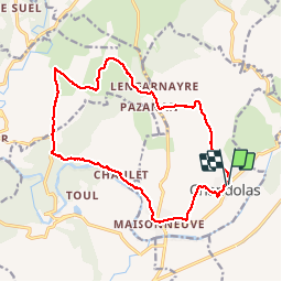
16,8 km

Max. hoogte
246 m

Positief hoogteverschil
315 m
Km-Effort
21 km

Min. hoogte
113 m

Negatief hoogteverschil
315 m
Boucle
Ja
Datum van aanmaak :
2019-04-26 19:24:55.049
Laatste wijziging :
2019-04-26 19:24:55.049
4h32
Moeilijkheid : Onbekend

Gratisgps-wandelapplicatie
 SityTrail
IGN / Geografische instituten
SityTrail Plus
De wereld gaat voor u open
Over ons
Tocht Stappen van 16,8 km beschikbaar op Auvergne-Rhône-Alpes, Ardèche, Chandolas. Deze tocht wordt voorgesteld door Lustou.
Beschrijving
Rando du 6/02/2017
Plaatsbepaling
Land:
France
Regio :
Auvergne-Rhône-Alpes
Departement/Provincie :
Ardèche
Gemeente :
Chandolas
Locatie:
Unknown
Vertrek:(Dec)
Vertrek:(UTM)
599808 ; 4917432 (31T) N.
Opmerkingen