


Monteaux - Onzain - via GR - 21km 175m 4h30 (30mn) - 2018 11 03

Orcal37
Gebruiker GUIDE
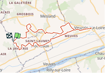

Lengte
21 km

Max. hoogte
107 m

Positief hoogteverschil
197 m
Km-Effort
24 km

Min. hoogte
61 m

Negatief hoogteverschil
198 m
Boucle
Ja
Datum van aanmaak :
2019-05-07 01:53:00.275
Laatste wijziging :
2021-08-30 10:38:01.722
4h30
Moeilijkheid : Gemakkelijk

Gratisgps-wandelapplicatie
 SityTrail
IGN / Geografische instituten
SityTrail Plus
De wereld gaat voor u open
Over ons
Tocht Stappen van 21 km beschikbaar op Centre-Val de Loire, Loir-et-Cher, Mesland. Deze tocht wordt voorgesteld door Orcal37.
Beschrijving
Monteaux - Onzain - via GR (photos délimitent GR) - 21km 175m 4h30 (30mn) - 2018 11 03
Foto's
 - 2018 11 03 - Photo 1")
 - 2018 11 03 - Photo 2")
Plaatsbepaling
Land:
France
Regio :
Centre-Val de Loire
Departement/Provincie :
Loir-et-Cher
Gemeente :
Mesland
Locatie:
Unknown
Vertrek:(Dec)
Vertrek:(UTM)
355566 ; 5261278 (31T) N.
Opmerkingen