


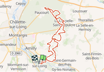
Rando du 15 aout 2008 - Conflans sur Loing

tracegps
Gebruiker

Lengte
41 km

Max. hoogte
146 m

Positief hoogteverschil
431 m
Km-Effort
47 km

Min. hoogte
91 m

Negatief hoogteverschil
434 m
Boucle
Ja
Datum van aanmaak :
2014-12-10 00:00:00.0
Laatste wijziging :
2014-12-10 00:00:00.0
2h30
Moeilijkheid : Medium

Gratisgps-wandelapplicatie
 SityTrail
IGN / Geografische instituten
SityTrail Plus
De wereld gaat voor u open
Over ons
Tocht Mountainbike van 41 km beschikbaar op Centre-Val de Loire, Loiret, Conflans-sur-Loing. Deze tocht wordt voorgesteld door tracegps.
Beschrijving
Circuit très agréable le long du Loing surtout en été ou en automne. Quelques montées un peu techniques.
Foto's

Plaatsbepaling
Land:
France
Regio :
Centre-Val de Loire
Departement/Provincie :
Loiret
Gemeente :
Conflans-sur-Loing
Locatie:
Unknown
Vertrek:(Dec)
Vertrek:(UTM)
484092 ; 5311066 (31T) N.
Opmerkingen
saint bris le vineux