


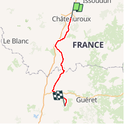
2 chateauroux Bénévent l'abbaye

henri.cordier
Gebruiker

Lengte
112 km

Max. hoogte
484 m

Positief hoogteverschil
1716 m
Km-Effort
134 km

Min. hoogte
105 m

Negatief hoogteverschil
1388 m
Boucle
Neen
Datum van aanmaak :
2014-12-10 00:00:00.0
Laatste wijziging :
2014-12-10 00:00:00.0
--
Moeilijkheid : Onbekend

Gratisgps-wandelapplicatie
 SityTrail
IGN / Geografische instituten
SityTrail Plus
De wereld gaat voor u open
Over ons
Tocht Fiets van 112 km beschikbaar op Centre-Val de Loire, Indre, Châteauroux. Deze tocht wordt voorgesteld door henri.cordier.
Plaatsbepaling
Land:
France
Regio :
Centre-Val de Loire
Departement/Provincie :
Indre
Gemeente :
Châteauroux
Locatie:
Unknown
Vertrek:(Dec)
Vertrek:(UTM)
400594 ; 5184917 (31T) N.
Opmerkingen