


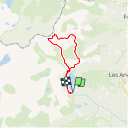
Les Pérics

xav34830
Gebruiker

Lengte
21 km

Max. hoogte
2794 m

Positief hoogteverschil
1077 m
Km-Effort
35 km

Min. hoogte
2002 m

Negatief hoogteverschil
1075 m
Boucle
Ja
Datum van aanmaak :
2014-12-10 00:00:00.0
Laatste wijziging :
2014-12-10 00:00:00.0
--
Moeilijkheid : Medium

Gratisgps-wandelapplicatie
 SityTrail
IGN / Geografische instituten
SityTrail Plus
De wereld gaat voor u open
Over ons
Tocht Stappen van 21 km beschikbaar op Occitanië, Pyrénées-Orientales, Les Angles. Deze tocht wordt voorgesteld door xav34830.
Plaatsbepaling
Land:
France
Regio :
Occitanië
Departement/Provincie :
Pyrénées-Orientales
Gemeente :
Les Angles
Locatie:
Unknown
Vertrek:(Dec)
Vertrek:(UTM)
418194 ; 4712354 (31T) N.
Opmerkingen
difficile
un parcours en boucle intéressant pour accéder aux 2 sommets. le passage en crête est escarpé, aérien et demande un pied sûr.