


chanac le causse

tyntyn
Gebruiker
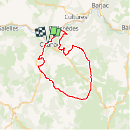

Lengte
27 km

Max. hoogte
936 m

Positief hoogteverschil
564 m
Km-Effort
34 km

Min. hoogte
638 m

Negatief hoogteverschil
556 m
Boucle
Ja
Datum van aanmaak :
2019-05-30 18:23:26.049
Laatste wijziging :
2019-05-30 18:23:26.169
--
Moeilijkheid : Onbekend

Gratisgps-wandelapplicatie
 SityTrail
IGN / Geografische instituten
SityTrail Plus
De wereld gaat voor u open
Over ons
Tocht Andere activiteiten van 27 km beschikbaar op Occitanië, Lozère, Chanac. Deze tocht wordt voorgesteld door tyntyn.
Plaatsbepaling
Land:
France
Regio :
Occitanië
Departement/Provincie :
Lozère
Gemeente :
Chanac
Locatie:
Chanac
Vertrek:(Dec)
Vertrek:(UTM)
527138 ; 4923816 (31T) N.
Opmerkingen