Tocht Stappen Montauriol - Montauriol : les points de vue. - Photo

Montauriol : les points de vue.

 prehault
prehault

Gebruiker

© OpenStreetMap contributors
Lengte
Lengte
4 km
Max. hoogte
Max. hoogte
280 m
Positief hoogteverschil
101 m
Km-Effort
Km-Effort  
5,3 km
Min. hoogte
Min. hoogte
194 m
Negatief hoogteverschil
105 m
Boucle
Boucle
Ja
Datum van aanmaak :
2014-12-10 00:00:00.0
Laatste wijziging :
2014-12-10 00:00:00.0

(4 Bericht)

Stappen
Stappen
1h08
Moeilijkheid : Gemakkelijk

Scan deze QR-code om de tocht te openen in de SityTrail-applicatie

Gratisgps-wandelapplicatie

Logo SityTrail SityTrail

IGN / Geografische instituten

SityTrail uit de App Store downloaden SityTrail uit Google Play downloaden

Logo SityTrail SityTrail World

De wereld gaat voor u open

SityTrail uit de App Store downloaden SityTrail uit Google Play downloaden SityTrail op Huawei AppGallery downloaden

Over ons

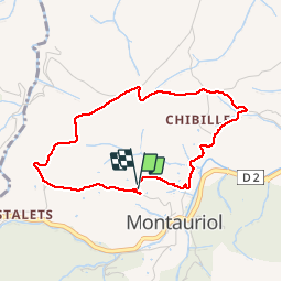
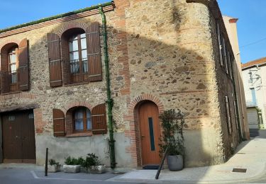
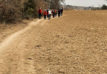
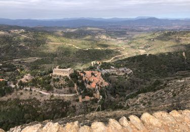
Tocht Stappen van 4 km beschikbaar op Occitanië, Pyrénées-Orientales, Montauriol. Deze tocht wordt voorgesteld door prehault.

Beschrijving

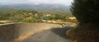
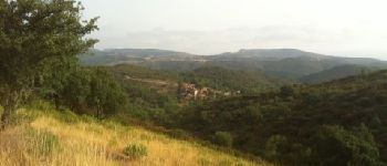
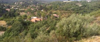
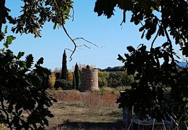
Petit circuit offrant de beaux points de vue sur le Canigou, sur Montauriol et sur la plaine côtière, jusqu'à la mer.

Hoogteprofiel

Foto's

POI's

POI Montauriol - Point 1 - Photo
prehault
MONTAURIOL 
POI Montauriol - Point 2 - Photo
prehault
MONTAURIOL 
POI Montauriol - Point 3 - Photo
prehault
MONTAURIOL 
POI Montauriol - Point 5 - Photo
prehault
MONTAURIOL 
POI Montauriol - Point 6 - Photo
prehault
MONTAURIOL 
POI Montauriol - Point 7 - Photo
prehault
MONTAURIOL 
POI Montauriol - Point 8 - Photo
prehault
MONTAURIOL 

Plaatsbepaling

Land:
France
Regio :
Occitanië
Departement/Provincie :
Pyrénées-Orientales
Gemeente :
Montauriol
Locatie:
Unknown
Vertrek:(Dec)
Vertrek:(UTM)
477160 ; 4713985 (31T) N.

Opmerkingen

Gelieve in te loggen om een commentaar of een beoordeling achter te laten


Petite balade toujours aussi agréable.


jolis point de vue eviter jour de vent


Wandeltochten in de omgeving

Tocht Stappen Tordères - 66 TORDÈRES - LLAURO, promenade en forêt méditerranéenne, cistes, genêts, bruyères. Arbousiers, chênes Lièges, chênes verts, pins - Photo
Stappen
jeff66

Stappen

Moeilijk
(1)
Tordères, Occitanië, Pyrénées-Orientales, France
11,9 km | 17,5 km-effort
2h 23min
Ja
Tocht Stappen Llupia - 66 LLUPIA - FOURQUES - TERRATS promenade dans les ASPRES et son vignoble  - Photo
Stappen
jeff66

Stappen

Medium
(1)
Llupia, Occitanië, Pyrénées-Orientales, France
15 km | 18,2 km-effort
2h 36min
Ja
Tocht Stappen Fourques - Fourques  - Photo
Stappen
Fildesir

Stappen

Heel gemakkelijk
(1)
Fourques, Occitanië, Pyrénées-Orientales, France
14,2 km | 16,4 km-effort
5h 17min
Ja
Tocht Stappen Castelnou - Thuir  - Photo
Stappen
Jean-François BALANGER

Stappen

Heel gemakkelijk
(1)
Castelnou, Occitanië, Pyrénées-Orientales, France
9,3 km | 12,1 km-effort
4h 4min
Neen
Tocht Stappen Castelnou - castel nous  - Photo
Stappen
Jean-François BALANGER

Stappen

Heel gemakkelijk
(1)
Castelnou, Occitanië, Pyrénées-Orientales, France
11,9 km | 16,7 km-effort
4h 0min
Ja
Tocht Stappen Llauro - Col de Llauro- Roc del Quers - Photo
Stappen
perittel

Stappen

Gemakkelijk
(1)
Llauro, Occitanië, Pyrénées-Orientales, France
8,9 km | 12,9 km-effort
3h 11min
Ja
Tocht Stappen Fourques - fourques sentier des histoires  - Photo
Stappen
66Gribouille83

Stappen

Medium
Fourques, Occitanië, Pyrénées-Orientales, France
9,1 km | 10,9 km-effort
2h 47min
Ja
Tocht Stappen Fourques - fourques - Photo
Stappen
66Gribouille83

Stappen

Medium
Fourques, Occitanië, Pyrénées-Orientales, France
7,9 km | 9,3 km-effort
3h 13min
Ja
Tocht Stappen Sainte-Colombe-de-la-Commanderie - 20230316 Sté Colombe-Castelnou - Photo
Stappen
ThonyM

Stappen

Medium
Sainte-Colombe-de-la-Commanderie, Occitanië, Pyrénées-Orientales, France
16,3 km | 23 km-effort
3h 55min
Ja


Sluiten
Mijn abonnementen