


Tellin2

jmvvk
Gebruiker
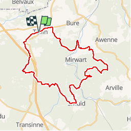

Lengte
34 km

Max. hoogte
487 m

Positief hoogteverschil
829 m
Km-Effort
45 km

Min. hoogte
243 m

Negatief hoogteverschil
836 m
Boucle
Ja
Datum van aanmaak :
2014-12-10 00:00:00.0
Laatste wijziging :
2014-12-10 00:00:00.0
3h28
Moeilijkheid : Medium

Gratisgps-wandelapplicatie
 SityTrail
IGN / Geografische instituten
SityTrail Plus
De wereld gaat voor u open
Over ons
Tocht Mountainbike van 34 km beschikbaar op Wallonië, Luxemburg, Tellin. Deze tocht wordt voorgesteld door jmvvk.
Beschrijving
Raando
Plaatsbepaling
Land:
Belgium
Regio :
Wallonië
Departement/Provincie :
Luxemburg
Gemeente :
Tellin
Locatie:
Tellin
Vertrek:(Dec)
Vertrek:(UTM)
658487 ; 5549908 (31U) N.
Opmerkingen