


Malbuisson

i20
Gebruiker

Lengte
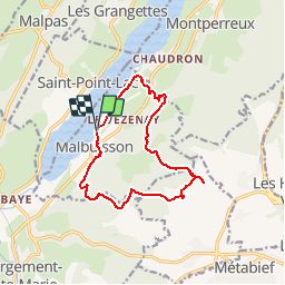
13 km

Max. hoogte
1094 m

Positief hoogteverschil
379 m
Km-Effort
18 km

Min. hoogte
848 m

Negatief hoogteverschil
380 m
Boucle
Ja
Datum van aanmaak :
2014-12-10 00:00:00.0
Laatste wijziging :
2014-12-10 00:00:00.0
3h13
Moeilijkheid : Medium

Gratisgps-wandelapplicatie
 SityTrail
IGN / Geografische instituten
SityTrail Plus
De wereld gaat voor u open
Over ons
Tocht Stappen van 13 km beschikbaar op Bourgondië-Franche-Comté, Doubs, Malbuisson. Deze tocht wordt voorgesteld door i20.
Plaatsbepaling
Land:
France
Regio :
Bourgondië-Franche-Comté
Departement/Provincie :
Doubs
Gemeente :
Malbuisson
Locatie:
Unknown
Vertrek:(Dec)
Vertrek:(UTM)
294362 ; 5186749 (32T) N.
Opmerkingen