


2012-10-10 Rando CVA Vosges du Nord

holtzv
Gebruiker GUIDE
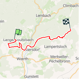

Lengte
18,1 km

Max. hoogte
468 m

Positief hoogteverschil
508 m
Km-Effort
25 km

Min. hoogte
170 m

Negatief hoogteverschil
510 m
Boucle
Neen
Datum van aanmaak :
2014-12-10 00:00:00.0
Laatste wijziging :
2014-12-10 00:00:00.0
--
Moeilijkheid : Onbekend

Gratisgps-wandelapplicatie
 SityTrail
IGN / Geografische instituten
SityTrail Plus
De wereld gaat voor u open
Over ons
Tocht Paard van 18,1 km beschikbaar op Grand Est, Bas-Rhin, Langensoultzbach. Deze tocht wordt voorgesteld door holtzv.
Plaatsbepaling
Land:
France
Regio :
Grand Est
Departement/Provincie :
Bas-Rhin
Gemeente :
Langensoultzbach
Locatie:
Unknown
Vertrek:(Dec)
Vertrek:(UTM)
406729 ; 5424777 (32U) N.
Opmerkingen