


port s'y laurent

LUTATIS
Gebruiker
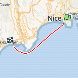

Lengte
11,3 km

Max. hoogte
0 m

Positief hoogteverschil
0 m
Km-Effort
11,3 km

Min. hoogte
0 m

Negatief hoogteverschil
0 m
Boucle
Neen
Datum van aanmaak :
2016-03-09 00:00:00.0
Laatste wijziging :
2016-03-09 00:00:00.0
51m
Moeilijkheid : Onbekend

Gratisgps-wandelapplicatie
 SityTrail
IGN / Geografische instituten
SityTrail Plus
De wereld gaat voor u open
Over ons
Tocht Andere activiteiten van 11,3 km beschikbaar op Provence-Alpes-Côte d'Azur, Alpes-Maritimes, Nice. Deze tocht wordt voorgesteld door LUTATIS.
Plaatsbepaling
Land:
France
Regio :
Provence-Alpes-Côte d'Azur
Departement/Provincie :
Alpes-Maritimes
Gemeente :
Nice
Locatie:
Unknown
Vertrek:(Dec)
Vertrek:(UTM)
362080 ; 4838941 (32T) N.
Opmerkingen