


les hauts de boeufs

nathycandy
Gebruiker
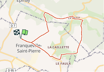

Lengte
8,7 km

Max. hoogte
161 m

Positief hoogteverschil
131 m
Km-Effort
10,4 km

Min. hoogte
51 m

Negatief hoogteverschil
131 m
Boucle
Ja
Datum van aanmaak :
2014-12-10 00:00:00.0
Laatste wijziging :
2014-12-10 00:00:00.0
1h56
Moeilijkheid : Gemakkelijk

Gratisgps-wandelapplicatie
 SityTrail
IGN / Geografische instituten
SityTrail Plus
De wereld gaat voor u open
Over ons
Tocht Stappen van 8,7 km beschikbaar op Normandië, Seine-Maritime, Franqueville-Saint-Pierre. Deze tocht wordt voorgesteld door nathycandy.
Plaatsbepaling
Land:
France
Regio :
Normandië
Departement/Provincie :
Seine-Maritime
Gemeente :
Franqueville-Saint-Pierre
Locatie:
Unknown
Vertrek:(Dec)
Vertrek:(UTM)
367821 ; 5474239 (31U) N.
Opmerkingen