


O2bikers_129_ Seraing

O2 bikers
Randonnées de O2bikers GUIDE+
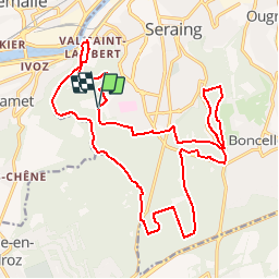

Lengte
22 km

Max. hoogte
277 m

Positief hoogteverschil
379 m
Km-Effort
27 km

Min. hoogte
66 m

Negatief hoogteverschil
377 m
Boucle
Ja
Datum van aanmaak :
2014-12-11 00:00:00.0
Laatste wijziging :
2014-12-11 00:00:00.0
3h21
Moeilijkheid : Onbekend

Gratisgps-wandelapplicatie
 SityTrail
IGN / Geografische instituten
SityTrail Plus
De wereld gaat voor u open
Over ons
Tocht Mountainbike van 22 km beschikbaar op Wallonië, Luik, Seraing. Deze tocht wordt voorgesteld door O2 bikers.
Plaatsbepaling
Land:
Belgium
Regio :
Wallonië
Departement/Provincie :
Luik
Gemeente :
Seraing
Locatie:
Seraing
Vertrek:(Dec)
Vertrek:(UTM)
675895 ; 5606120 (31U) N.
Opmerkingen